Detail View: Old Maps Collection: [Carte d'une partie de la mer de Chine]
|
Barcode:
|
3687800354286H
|
|
Title:
|
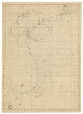
[Carte d'une partie de la mer de Chine]
|
|
Category:
|
Sea Charts
|
|
Type:
|
Manuscripts
|
|
Create Year:
|
[ca. 1796]
|
|
Format:
|
JPEG 2000, 8489 × 11583, 13MB
|
|
Scale:
|
Scale not given.
|
|
Physical Map Dimension (cm):
|
69 x 49 cm, on sheet 81 x 55 cm
|
|
Note:
|
This is a hydrographic chart of the South China Sea that has the exact same outline of the map 'Carte d'une partie de la mer de Chine' made accordingly to the observations of the French Vice Admiral Rosili. He spent seven years doing hydrographic work in the Red Sea, the Indian Ocean and the seas off China. Even though this manuscript chart is a lot more simplified than the printed one, it still depicts the northeastern part of the China Sea, with the Pearl River delta, part of the coast of southern China, the Hainan Island, the coast of Vietnam and part of the coast of Cambodia. All the inland is blank with no nomenclature whatsoever on the chart. The Paracel Islands, and other islets and reefs are also included and some of the marked routes either end or begin at the islands on the mouth of the Delta river, and most probably Macau.
|
|
Note:
|
Original is a manuscript map with graticule in red.
|
|
Note:
|
Bathymetric relief shown by soundings.
|
|
Note:
|
The four borders of the map with latitude and longitude lines.
|
|
Note:
|
Map with graticule.
|
|
Note:
|
Outlined in simple fillet.
|
|
Subject:
|
China -- Maps
|
|
Subject:
|
China Sea -- Maps
|
|
Geographic Area:
|
China
|
|
Geographic Area:
|
South China Sea
|
|
Geographic Area:
|
Vietnam
|
|
Geographic Area:
|
Hainan Sheng (China)
|
|
Geographic Area:
|
Paracel Islands
|
|
Geographic Area:
|
Cambodia
|
|
Provenance:
|
Bibliothèque Nationale de France
|
|
Provenance Call No.:
|
GE SH 18 PF 182 P 11 D
|
|
MUST holding:
|
https://must.primo.exlibrisgroup.com/permalink/853MUST_INST/171sgkf/alma991002988849805076
|