Detail View: Old Maps Collection: [Route de M. de Richery en 1787 de Pondichery a Canton]
|
Barcode:
|
4687820501172
|
|
Title:
|
[Route de M. de Richery en 1787 de Pondichery a Canton]
|
|
Category:
|
Sea Charts
|
|
Type:
|
Manuscripts
|
|
Language:
|
French
|
|
Create Year:
|
1787
|
|
Format:
|
JPEG 2000, 10844 × 7798, 86MB
|
|
Scale:
|
Scale not given.
|
|
Physical Map Dimension (cm):
|
35 x 58 cm, on sheet 56 x 74 cm
|
|
Note:
|
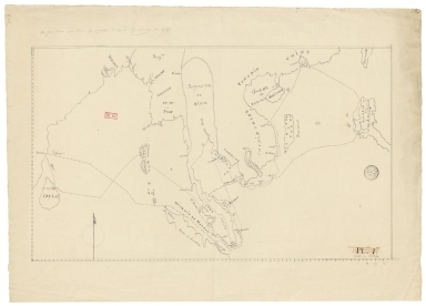
This is a simplified yet fairly accurate chart of the East Indies. On the map it is marked the route from Richery (fl. 1800), a hydrographer and a naval officer commanding the ship Marquis-de-Castries in 1787. The route is from Puducherry in India -marked as 'Pondichery' on the map- to the Philippines and back via Macau. The route goes trough the Strait of Malacca, as was common at the time, then following the Malay coast until Cambodia, then to the Vietnamese Pulo Condor and Pulo Sapate, Con Son and Hon Hai respectively, until the Philippines. On the way back, the ship goes to Macau and then to the coast of Vietnam, avoiding the Paracels and always close to the coast line, again through the Malacca Strait to Ceylon -modern day Sri Lanka- and finally to Puducherry.
|
|
Note:
|
Original is a manuscript map.
|
|
Note:
|
Compass rose drawn in pincel on the map with a flag indicating north.
|
|
Note:
|
Latitude line on the left border of the map and longitude line on the bottom border.
|
|
Note:
|
Map outlined in double fillet.
|
|
Note:
|
Macao in East Indies maps.
|
|
Note:
|
Macao in routes.
|
|
Geographic Area:
|
Macao (China)
|
|
Geographic Area:
|
Ceylon
|
|
Geographic Area:
|
Sri Lanka
|
|
Geographic Area:
|
Bay of Bengal
|
|
Geographic Area:
|
Indian Ocean
|
|
Geographic Area:
|
Myanmar
|
|
Geographic Area:
|
Malacca (Malacca, Malaysia)
|
|
Geographic Area:
|
Strait of Malacca
|
|
Geographic Area:
|
Andaman Sea
|
|
Geographic Area:
|
Sumatra (Indonesia)
|
|
Geographic Area:
|
Cambodia
|
|
Geographic Area:
|
Thailand
|
|
Geographic Area:
|
Vietnam
|
|
Geographic Area:
|
Paracel Islands
|
|
Geographic Area:
|
Gulf of Tonkin
|
|
Geographic Area:
|
South China Sea
|
|
Geographic Area:
|
China
|
|
Geographic Area:
|
Philippines
|
|
Geographic Area:
|
Taiwan
|
|
Geographic Area:
|
Hainan Sheng (China)
|
|
Provenance:
|
Bibliothèque Nationale de France
|
|
Provenance Call No.:
|
GE SH 18 PF 182 P 6 D
|
|
MUST holding:
|
https://must.primo.exlibrisgroup.com/permalink/853MUST_INST/171sgkf/alma991002989248605076
|