Detail View: Old Maps Collection: South China Coast from St. John Island to the Lamma Islands
|
Barcode:
|
3687800354678M
|
|
Title:
|
South China Coast from St. John Island to the Lamma Islands
|
|
Original Title:
|
[Côte de Chine méridionale de l'île St. John aux îles Lema]
|
|
Other Title:
|
Isle du milieu en Chinois
|
|
Category:
|
Sea Charts
|
|
Type:
|
Manuscripts
|
|
Language:
|
French
|
|
Create Year:
|
[17--]
|
|
Format:
|
JPEG 2000, 6140 × 4708, 48MB
|
|
Scale:
|
Scale not given.
|
|
Physical Map Dimension (cm):
|
38 x 50 cm, on sheet 45 x 57 cm
|
|
Note:
|
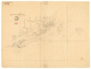
This is a manuscript chart of Macao and its surroundings extending from Sangchuan (Changchem ou S.t John) on the west to Lamma Island (I. Lema) on the east and the only two places identified on the original drawing. The map clearly has a navigational intent with most of the places named being small islands known for position purposes, some accompanied with latitude and longitude degrees. The Macao Peninsula and Qianshan are the only places where appear buildings. Coloane was missing on the original sketch but was later added in pencil.
|
|
Note:
|
Original is a manuscript map, 39 x 50 cm.
|
|
Note:
|
Title from provenance library.
|
|
Note:
|
Bathymetric relief given by soundings.
|
|
Note:
|
Map with grid.
|
|
Note:
|
Map mainly in French with some place names in English.
|
|
Note:
|
Macao and its surroundings.
|
|
Note:
|
Macao in routes.
|
|
Subject:
|
China -- Maps
|
|
Geographic Area:
|
Pearl River Estuary (China)
|
|
Geographic Area:
|
Shangchuan Island
|
|
Geographic Area:
|
Dangan Island
|
|
Geographic Area:
|
Macao
|
|
Provenance:
|
Bibliothèque Nationale de France
|
|
Provenance:
|
https://catalogue.bnf.fr/ark:/12148/cb443589093
|
|
Provenance Call No.:
|
GE SH 18 PF 179 DIV 3 P 7 D
|
|
MUST holding:
|
https://must.primo.exlibrisgroup.com/permalink/853MUST_INST/171sgkf/alma991003073549705076
|