Detail View: Old Maps Collection: Plan de la ville et des environs de Macao
|
Barcode:
|
4687820501168
|
|
Title:
|
Plan de la ville et des environs de Macao
|
|
Contributor:
|
Dupont, Paul-François, 1796-1879, lithographer
|
|
Category:
|
Sea Charts
|
|
Type:
|
Manuscripts
|
|
Language:
|
French
|
|
Create Year:
|
[1846]
|
|
Format:
|
JPEG 2000, 4456 × 3576, 29MB
|
|
Scale:
|
Scale not given.
|
|
Physical Map Dimension (cm):
|
24 x 24 cm, on sheet 28 x 35 cm
|
|
Note:
|
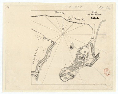
his is a plan of the Macau Peninsula with the Green Island, part of Lapa or Priest's Island (Ile des Prêtres) and Xiangshan (Ile Heang-Shan). On the city of Macau the buildings appear geometric, typical of a plan, with focus given to Mount Fort. 57 places are numbered both in Macau and Lapa even though no legend is given. On Xiangshan, Casa Branca is identified by a drawing of a small house next to a pagoda.
|
|
Note:
|
Original is a lithograph, 24 x 24 cm, on sheet 28 x 35 cm.
|
|
Note:
|
On the right corner of the map: "Lith. P. Dupont, rue Grenelle S.t Honoré, 55."
|
|
Note:
|
There is a 16-point compass rose with an arrow indicating north.
|
|
Note:
|
Relief shown by hachures, pictorially and rock drawing.
|
|
Note:
|
Map outlined in simple fillet.
|
|
Note:
|
City plans of Macao.
|
|
Reference:
|
Montigny, M.C. Manuel du négociant français en Chine, ou Commerce de la Chine considéré au point de vue français, p. 283
|
|
Subject:
|
Macao (China) -- Maps
|
|
Geographic Area:
|
Macao (China)
|
|
Provenance:
|
Bibliothèque Nationale de France
|
|
Provenance:
|
https://catalogue.bnf.fr/ark:/12148/cb43637964z
|
|
Provenance Call No.:
|
GE DL 1846-54
|
|
MUST holding:
|
https://must.primo.exlibrisgroup.com/permalink/853MUST_INST/171sgkf/alma991000825489705076
|