Detail View: Old Maps Collection: The West River from Chinese maps
|
Barcode:
|
4687820501167
|
|
Title:
|
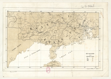
The West River from Chinese maps
|
|
Contributor:
|
Litografía de Oppel y Compañía (Manila) lithographer
|
|
Category:
|
General Maps
|
|
Type:
|
Printed
|
|
Language:
|
English
|
|
Create Year:
|
[ca. 1870]
|
|
Format:
|
JPEG 2000, 4888 × 3496, 32MB
|
|
Scale:
|
[ca. 1:2,700,000].
|
|
Physical Map Dimension (cm):
|
23 x 37 cm, on sheet 29 x 41 cm
|
|
Note:
|
The map depicts the coast line of South China extending from the Gulf of Tonkin until Hong Kong, with the north part of the Hainan Island. On the map can be seen the many rivers of the Guangxi Region with focus on the West River and, according to the legend on the bottom right corner, are also marked Fu, Chau, Ting and Hien (different administrative units).
|
|
Note:
|
Original is a lithography, 24 x 38 cm.
|
|
Note:
|
Map with graticule.
|
|
Note:
|
The four borders of the map with latitude and longitude lines.
|
|
Note:
|
Map outlined in simple fillet.
|
|
Note:
|
Macao in China maps.
|
|
Geographic Area:
|
Guangdong Sheng (China)
|
|
Geographic Area:
|
Guangxi Zhuangzu Zizhiqu (China)
|
|
Geographic Area:
|
Hainan Sheng (China)
|
|
Geographic Area:
|
China
|
|
Geographic Area:
|
South China Sea
|
|
Geographic Area:
|
Gulf of Tonkin
|
|
Provenance:
|
Bibliothèque Nationale de France
|
|
Provenance:
|
https://catalogue.bnf.fr/ark:/12148/cb40633877n
|
|
Provenance Call No.:
|
GE D-21708
|
|
MUST holding:
|
https://must.primo.exlibrisgroup.com/permalink/853MUST_INST/171sgkf/alma991002993049805076
|