Detail View: Old Maps Collection: Plan of the Typa near Macao in China
|
Barcode:
|
4687820500137
|
|
Title:
|
Plan of the Typa near Macao in China
|
|
Contributor:
|
Baker, George, 1781-1851, cartographer
|
|
Category:
|
Thematic Maps
|
|
Type:
|
Printed
|
|
Language:
|
English
|
|
Create Year:
|
1780
|
|
Format:
|
JPEG 9162 × 6070, 57.1MB
|
|
Page No.:
|
12
|
|
Scale:
|
Scale not given.
|
|
Physical Map Dimension (cm):
|
28 x 38 cm
|
|
Note:
|
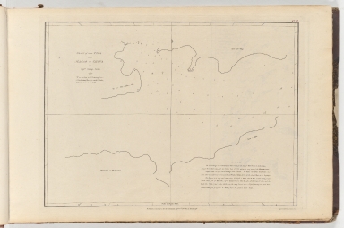
Hydrographic map of the Typa harbor showing depth by soundings. The map has a developed note on the right bottom corner that explains the depth of the water in different times of the year and of the day. It also clarifies the places prone to stranding. The English up to 1700 tried to establish direct trade with China, but without any success. This particular map was made at a time when the English trade started to really develop in China and Macao so charts like these were essential for a safe navigation trough the known low waters of Macao.
|
|
Note:
|
Original is a printed map from the book 'Collection of plans of ports in the East Indies', 30 x 38 cm.
|
|
Note:
|
On the right bottom corner: "Engrav'd by Harmar 63 Chandos Street."
|
|
Note:
|
There is a 4-point compass rose that crosses the whole map with a half fleur de lis indicating north.
|
|
Note:
|
Scale line on the bottom of the map in nautic miles.
|
|
Note:
|
Bathymetric relief is shown by soundings.
|
|
Note:
|
Map outlined in double fillet.
|
|
Note:
|
Macao ad its surroundings.
|
|
Subject:
|
River surveys
|
|
Geographic Area:
|
Macao (China)
|
|
Geographic Area:
|
Taipa Island (China)
|
|
Relation Note:
|
Vol. 2, n.º 12
|
|
Pub Title:
|
Collection of plans of ports in the East Indies
|
|
Pub Year:
|
1774-1791
|
|
Pub location:
|
London
|
|
Provenance:
|
Harvard College Library
|
|
Provenance:
|
http://id.lib.harvard.edu/alma/990050430870203941/catalog
|
|
Provenance Call No.:
|
GEN MA 18.74 pf*
|
|
MUST holding:
|
https://must.primo.exlibrisgroup.com/permalink/853MUST_INST/171sgkf/alma991000043149705076
|