Detail View: Old Maps Collection: Views of the coasts of China
|
Barcode:
|
3687800354652E
|
|
Title:
|
Views of the coasts of China
|
|
Original Title:
|
[Vues des côtes de la Chine, sections numérotées de 16 à 24]
|
|
Other Title:
|
Lantao, Chulapko Isl.de; Tsa-Chow; Loonkoo.
|
|
Other Title:
|
Cowhee Island, Lantao Island.
|
|
Other Title:
|
Botow Isl.ds, Tysa-Rock; Chulapko Islands, Ragged I., Long Island; Lantao Island; Tsa-Chow Islands; Loonkoo, Lintin Peak.
|
|
Other Title:
|
Tsa-Chow Isl.ds, Peakd I., Gap I., Loonkoo Island; Lintin Isl.d; Little Great; Singan Isl.ds Peakd I., Great, Castle Land.
|
|
Other Title:
|
Lantao Island, Long I., Lantao Peak, Loonkoo, Gap Rock, Rock, Longshitow, Gap of Laf-sammee, Gr. Ladron Peak; Changehow & c.; Lintin Island; L. Mew, G. Mew; Singan Islands, Peakd I. Hum I., Great Island.
|
|
Other Title:
|
Lintin Island, Great Mew, Little Mew.
|
|
Other Title:
|
N.º Singran; Flat Singran; Great N.º Singrau; Reef Island; Great Singran; Hum Peaked Singran.
|
|
Other Title:
|
Lintin Peak; Gap of Tyger I.
|
|
Other Title:
|
Castle Island; Tyger Island; Island to N.d of Tyger Island.
|
|
Other Title:
|
View of Lintin and the Nine Islands; Yeali-tcheow, Tong-kow-wan, Popau-tchow, Heun-kow-tchow, Tak-phoong-kong, Taikow-tchow, Two Isl.ds, Wang-kow-tchow, Lintin.
|
|
Contributor:
|
Great Britain. Hydrographic Office, author
|
|
Contributor:
|
Dalrymple, Alexander, 1737-1808, publisher
|
|
Category:
|
Sea Charts
|
|
Type:
|
Printed
|
|
Language:
|
English
|
|
Create Year:
|
1780
|
|
Format:
|
JPEG 2000, 7848 × 3064, 41MB
|
|
Scale:
|
Scale not given.
|
|
Physical Map Dimension (cm):
|
23 x 65 cm, on sheet 32 x 71 cm
|
|
Note:
|
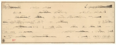
This is a view of some profiles of the islands on the South China Sea, particularly near Lantao and Lintin. But also includes some of the islands in the Pearl River estuary specially near Dahu dao and Humen. The profiles accompany the voyage of a British ship on 20th to 22nd November 1764.
|
|
Note:
|
N. 16: Lantao, Chulapko Isl.de; Tsa-Chow; Loonkoo. - Scale not given. - 2 x 27 cm. - Cowhee Island, Lantao Island. -- N. 17: Botow Isl.ds, Tysa-Rock; Chulapko Islands, Ragged I., Long Island; Lantao Island; Tsa-Chow Islands; Loonkoo, Lintin Peak. - Scale not given. - 1 x 53 cm. -- N. 18: Tsa-Chow Isl.ds, Peakd I., Gap I., Loonkoo Island; Lintin Isl.d; Little Great; Singan Isl.ds Peakd I., Great, Castle Land. - Scale not given. - 1 x 50 cm. -- N. 19: Lantao Island, Long I., Lantao Peak, Loonkoo, Gap Rock, Rock, Longshitow, Gap of Laf-sammee, Gr. Ladron Peak; Changehow & c.; Lintin Island; L. Mew, G. Mew; Singan Islands, Peakd I. Hum I., Great Island. - Scale not given. - 1 x 63 cm. -- N. 20: Lintin Island, Great Mew, Little Mew. - Scale not given. - 1 x 14 cm. -- N. 21: N.º Singran; Flat Singran; Great N.º Singrau; Reef Island; Great Singran; Hum Peaked Singran. - Scale not given. - 1 x 29 cm. -- N. 22: Lintin Peak; Gap of Tyger I.. - Scale not given. - 1 x 63 cm. -- N. 23: Castle Island; Tyger Island; Island to N.d of Tyger Island. - Scale not given. - 1 x 51 cm. -- N. 24: View of Lintin and the Nine Islands; Yeali-tcheow, Tong-kow-wan, Popau-tchow, Heun-kow-tchow, Tak-phoong-kong, Taikow-tchow, Two Isl.ds, Wang-kow-tchow, Lintin. - Scale not given. - 1 x 10 cm.
|
|
Note:
|
Original is a copperplate of profiles of islands and islets of the South China Sea, 25 x 65 cm.
|
|
Note:
|
Title from provenance library.
|
|
Note:
|
Relief shown by land forms.
|
|
Note:
|
Outlined in bold fillet.
|
|
Subject:
|
Coasts
|
|
Subject:
|
Profiles
|
|
Geographic Area:
|
China
|
|
Provenance:
|
Bibliothèque Nationale de France
|
|
Provenance:
|
https://catalogue.bnf.fr/ark:/12148/cb443578819
|
|
Provenance Call No.:
|
GE SH 18 PF 179 DIV 1 P 1 D
|
|
MUST holding:
|
https://must.primo.exlibrisgroup.com/permalink/853MUST_INST/171sgkf/alma991003032049805076
|