Detail View: Old Maps Collection: Reduced map of the Chinese Sea : 2nd sheet, containing the northern part
|
Barcode:
|
4687820501165
|
|
Title:
|
Reduced map of the Chinese Sea : 2nd sheet, containing the northern part
|
|
Original Title:
|
Reduzirte Karte vom Chinesischen Meere : 2.tes Blatt, den Nördlischen Theil enthaltend
|
|
Other Title:
|
Berghaus's Atlas von Asia
|
|
Other Title:
|
Golf von Tonkin.
|
|
Other Title:
|
Die Hainan Strasse.
|
|
Other Title:
|
Karte von der bucht von Fu-Tscheu.
|
|
Other Title:
|
Inseln Pong-hu.
|
|
Other Title:
|
Haf. der insel Camiguin.
|
|
Other Title:
|
Haf. von S.t Vincent.
|
|
Other Title:
|
Subec, Minangas.
|
|
Other Title:
|
Capones SP.
|
|
Other Title:
|
Haf. von Silanguin.
|
|
Other Title:
|
Pyramiden Insel.
|
|
Other Title:
|
Falsche Tinhosa.
|
|
Other Title:
|
Insel Tinhosa.
|
|
Other Title:
|
Sail Rock.
|
|
Other Title:
|
Cap Varela S.W. 7 Seemeilen.
|
|
Other Title:
|
Cap Varela N.S.W. 6 Seem.
|
|
Other Title:
|
Südende von Formosa.
|
|
Other Title:
|
Nord Baschi Inseln.
|
|
Other Title:
|
Vela Rete Felsen.
|
|
Other Title:
|
Busvagaon und die angrenzenden Inseln v.W.b.S. gen S.W. 1/4 W. 9 Seem.
|
|
Other Title:
|
Berg Calavite auf Mindoro.
|
|
Other Title:
|
Spitze Capones.
|
|
Contributor:
|
Jättnig, Wilhelm, fl. 1830-1839, engraver
|
|
Contributor:
|
Justus Perthes (Firm : Gotha, Germany), publisher
|
|
Category:
|
General Maps
|
|
Type:
|
Printed
|
|
Language:
|
German
|
|
Create Year:
|
1835
|
|
Format:
|
JPEG 2000, 10763 × 15389, 229.7MB
|
|
Page No.:
|
15
|
|
Scale:
|
[ca. 1:2,300,000].
|
|
Physical Map Dimension (cm):
|
51 x 77 cm, on sheet 62 x 88 cm
|
|
Note:
|
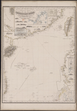
The map was published in the book 'Großer Atlas der Außereuropäischen Erdtheile' by Henrich Berghaus. He was a German geographer and cartographer, trained as a surveyor, who carried on a geographical school at Potsdam. Berghaus's written works were numerous and important. This particular map depicts the South China coast and the central and northern regions of the South China Sea. Several routes are given, and almost all of them from the Pearl River Estuary to Europe, America, and Southeast Asian countries, showing the important role of the Greater Bay Area, specially Macau, in trade and transportation between China and foreign countries at that time.
|
|
Note:
|
Inset 1: Golf von Tonkin. - Scale not given. - 22 x 10 cm. -- Inset 2: Die Hainan Strasse. - Scale indeterminable. - 7 x 11 cm. -- Inset 3: Karte von der bucht von Fu-Tscheu. - Scale indeterminable. - 14 x 17 cm. -- Inset 4: Inseln Pong-hu. - Scale not given. - 6 x 8 cm. -- Inset 5: Haf. der insel Camiguin. - Scale indeterminable. - 6 x 4 cm. -- Inset 6: Haf. von S.t Vincent. - Scale indeterminable. - 7 x 4 cm. -- Inset 7: Subec, Minangas. - Scale indeterminable. - 7 x 4 cm. -- Inset 8: Capones SP. - Scale indeterminable. - 5 x 5 cm. -- Inset 9: Haf. von Silanguin. - Scale indeterminable. - 4 x 5 cm.
其他題名
|
|
Note:
|
Original is a lithograph, 98 x 66 cm.
|
|
Note:
|
Underneath the title: "Gest. v. Wilh. Jättnig in Berlin." And on the left upper corner of the map: "Berghaus's Atlas von Asia".
|
|
Note:
|
There are 12 side views of the islands, coastlines, and shores: Pyramiden Insel; Falsche Tinhosa; Insel Tinhosa; Sail Rock; Cap Varela S.W. 7 Seemeilen; Cap Varela N.S.W. 6 Seem.; Südende von Formosa; Nord Baschi Inseln; Vela Rete Felsen; Busvagaon und die angrenzenden Inseln v.W.b.S. gen S.W. 1/4 W. 9 Seem.; Berg Calavite auf Mindoro; Spitze Capones.
|
|
Note:
|
On insets 5-9 there are 4-point compass roses with an arrow indicating north.
|
|
Note:
|
Title with scroll work elements.
|
|
Note:
|
Relief shown by hachures and land forms. Bathymetric relief by soundings.
|
|
Note:
|
The four borders of the main map and inset 1 with latitude and longitude lines in black and white interchangeably.
|
|
Note:
|
Main map and inset 4 with graticule.
|
|
Note:
|
Map outlined in triple fillet and insets in simple bold fillet.
|
|
Note:
|
Macao in China maps.
|
|
Subject:
|
Administrative and political divisions
|
|
Geographic Area:
|
China Sea
|
|
Geographic Area:
|
North Pacific Ocean
|
|
Geographic Area:
|
Southeast Asia
|
|
Relation Note:
|
N.º 15
|
|
Pub Title:
|
Großer Atlas der Außereuropäischen Erdtheile.
|
|
Pub Author:
|
Berghaus, Henrich, 1797-1884
|
|
Pub Year:
|
1832-1843
|
|
Pub location:
|
Gotha
|
|
Provenance:
|
Bibliothèque Nationale de France
|
|
Provenance:
|
https://catalogue.bnf.fr/ark:/12148/cb40882648n
|
|
Provenance Call No.:
|
GE CC-863 (15)
|
|
MUST holding:
|
https://must.primo.exlibrisgroup.com/permalink/853MUST_INST/171sgkf/alma991002988949605076
|