Detail View: Old Maps Collection: Il regno della China detto presentemente Catay, e Mangin, diviso sopra le Carte piú esatte nelle sue Principle Provincie
|
Barcode:
|
4687820501105
|
|
Title:
|
Il regno della China detto presentemente Catay, e Mangin, diviso sopra le Carte piú esatte nelle sue Principle Provincie
|
|
Contributor:
|
Cantelli, Giacomo, 1643-1695, cartographer
|
|
Contributor:
|
Grueber, Johann, 1623-1680 bibliographic antecedent
|
|
Contributor:
|
Góis, Bento de, 1562-1607, bibliographic antecedent
|
|
Contributor:
|
Martini, Martino, 1614-1661, bibliographic antecedent
|
|
Contributor:
|
Tavernier, Jean-Baptiste, 1605-1689, bibliographic antecedent
|
|
Contributor:
|
Widman, Georgio, fl. 1705, engraver
|
|
Contributor:
|
Rossi, Giovanni Giacomo de, 1627-1691, printer
|
|
Category:
|
General Maps
|
|
Type:
|
Printed
|
|
Language:
|
Italian
|
|
Language:
|
Portuguese
|
|
Language:
|
Spanish
|
|
Create Year:
|
1682
|
|
Format:
|
JPEG 2000, 10170 x 7648, 15MB
|
|
Scale:
|
Scale indeterminable.
|
|
Physical Map Dimension (cm):
|
43 x 54 cm, on sheet 56 x 74 cm
|
|
Note:
|
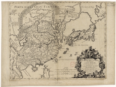
This map of the Chinese Empire is drawn largely from the Blaeu map compiled by Jesuit Father Martino Martini who traveled through the region between 1643 and 1650. However other important early sources are also mentioned as Tavernier, Johann Grueber and Bento de Góis. Individual provinces, towns, and the Great Wall are depicted. Korea is shown as a long, narrow peninsula with only a few place names which denotes the lack of knowledge of the country at the time. Japan is beginning to take shape, although Hokkaido is still connected to Tartary, labeled 'Tartari di Yupy' and completely blank. The Dutch settlement of New Zealand is shown in Taiwan named as 'Loqueio ò Formosa I.' The map extends south to include the northern part of the Philippine Island of Luzon and the city of Manila. Macao is marked but not Hong Kong denoting the early importance of the former but not the latter.
|
|
Note:
|
Original is a copperplate printed map, 43 x 54 cm.
|
|
Note:
|
On the right bottom corner of the map: "Giorgio Widman sculp."
|
|
Note:
|
Title cartouche on the right bottom corner of the map decorated with scrollwork and phytomorphic motives, sided on the bottom part by sirens and topped with a king with a scepter with a fleur de lis on his right hand.
Triple scale line in Italian miles, Chinese Li and Japanese leagues in black and white interchangeably.
|
|
Note:
|
Relief shown pictorially.
|
|
Note:
|
The four borders of the map with latitude and longitude lines in black and white interchangeably. And labelled with North, South, East and West in Italian Settentrione, Mezzo giorno, Levante and Ponente.
|
|
Note:
|
Map outlined in simple fillet.
|
|
Note:
|
Macao in China maps.
|
|
Subject:
|
China -- Maps
|
|
Geographic Area:
|
China
|
|
Geographic Area:
|
Japan
|
|
Geographic Area:
|
Hainan Sheng (China)
|
|
Geographic Area:
|
Korea
|
|
Geographic Area:
|
Philippines
|
|
Geographic Area:
|
Taiwan
|
|
Provenance:
|
Bibliothèque Nationale de France
|
|
Provenance:
|
https://catalogue.bnf.fr/ark:/12148/cb40682219m
|
|
Provenance Call No.:
|
GE D-5695
|
|
MUST holding:
|
https://must.primo.exlibrisgroup.com/permalink/853MUST_INST/171sgkf/alma991002993049705076
|