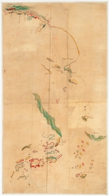
Detail View: Old Maps Collection: [Carte de la rivière de Canton]

|
Barcode:
|
4687820501104
|
|
Title:
|
[Carte de la rivière de Canton]
|
|
Category:
|
General Maps
|
|
Type:
|
Manuscripts
|
|
Language:
|
French
|
|
Create Year:
|
[17--]
|
|
Format:
|
JPEG2000, 6926 x 12404, 15MB
|
|
Scale:
|
Scale not given
|
|
Physical Map Dimension (cm):
|
102 x 55 cm, on sheet 112 x 66 cm
|
|
Note:
|
Very little in known about this manuscript nautical chart of the Pearl River made on the 18th century by an unknown author. It is a chart from the [Portefeuille 179 du Service hydrographique de la Marine consacré à la Chine] of the 'Service hydrographique de la Marine' belonging to the Bibliothèque Nationale de France. On the left upper corner of the map, near Canton, is depicted a building named only 'Temple' which refers to the Hoi Tong Temple -海幢寺-, a buddhist temple from the 10th century. To its left there are 3 numbered towers. The first tower identified as 'Tour de Lion' is the Lotus Pagoda -莲花塔- or Wenchang Pagoda built in 1612, a 8-corner brick-build architecture, 50m high, with 9 floors outside and 11 layers inside. The second one is Pazhou Pagoda -琶洲塔- also known as the Whampoa Pagoda, built in 1600 is an octagonal tower with 9 main sections and 17 sub sections with 59m high. The third and last one is the Chigang Pagoda -赤岗塔- or Red Stone Hill Pagoda. The pagoda built in 1619 is in octagonal shape, it stands 53.7m tall with 9 exterior floor sections and 17 interior levels. This three pagodas built at the mouth of the Pearl River are said to bring good luck to Guangzhou and the surrounding area.
|
|
Note:
|
Original is a manuscript watercolor map, 104 x 57 cm.
|
|
Note:
|
Title from the provenance library.
|
|
Note:
|
Relief is shown pictorially on land and bathymetric relief is given by soundings.
|
|
Note:
|
Roughly at the center there is a pencil drawn fleur-de-lis -maybe added later- indicating north.
|
|
Note:
|
The coats line and the islands are outlined in color.
|
|
Note:
|
Macao and its surroundings.
|
|
Subject:
|
China -- Maps
|
|
Geographic Area:
|
Pearl River Estuary (China)
|
|
Geographic Area:
|
Guangzhou Shi (China)
|
|
Geographic Area:
|
Macao (China)
|
|
Geographic Area:
|
Wanshan Archipelago
|
|
Geographic Area:
|
Shangchuan Island
|
|
Provenance:
|
Bibliothèque Nationale de France
|
|
Provenance:
|
https://catalogue.bnf.fr/ark:/12148/cb45089618q
|
|
Provenance Call No.:
|
GE SH 18 PF 179 DIV 9 P 5
|
|
MUST holding:
|
https://must.primo.exlibrisgroup.com/permalink/853MUST_INST/171sgkf/alma991002923849805076
|