Detail View: Old Maps Collection: Chart of the Pacific Ocean

|
Barcode:
|
3687800354648J
|
|
Title:
|
Chart of the Pacific Ocean
|
|
Original Title:
|
[Carte de l'Océan Pacifique]
|
|
Other Title:
|
Bengala.
|
|
Other Title:
|
Arracão.
|
|
Other Title:
|
Pegu.
|
|
Other Title:
|
Chatigão.
|
|
Contributor:
|
Albernaz, João Teixeira, I, fl. 1602-1649, cartographer
|
|
Category:
|
Sea Charts
|
|
Type:
|
Manuscripts
|
|
Language:
|
Portuguese
|
|
Create Year:
|
[1649]
|
|
Format:
|
JPEG 2000, 11160 x 9360, 20MB
|
|
Scale:
|
Scale not given.
|
|
Physical Map Dimension (cm):
|
74 x 91 cm, on sheet 78 x 93 cm
|
|
Note:
|
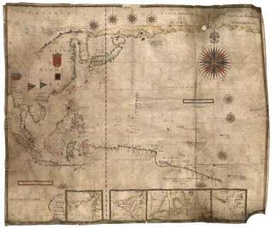
This is a sea chart with four insets on the bottom by cartographer, chart maker and cosmographer to the King of Portugal, João Teixeira Albernaz, from the long line of cartographers from the Teixeira family. The chart depicts the Pacific Ocean with insets of Bengal in India, two of Myanmar and another of Chittagong. East Asia is depicted already quite accurate with Japan in the Teixeira-type, made popular by Albernaz's father Luís Teixiera, and Korea as a Peninsula. However, the island of Hokkaido is still named 'Yezo', Papua New Guinea is greatly exaggerated, either because it was still unexplored or they thought it to be connected to Australia, and the Kamchatka Peninsula very outstretched. There is a Portuguese flag pointing to Macao.
|
|
Note:
|
Inset 1: Bengala. - Scale not given. - 10 x 12 cm. -- Inset 2: Arracão. - Scale not given. - 10 x 12 cm. -- Inset 3: Pegu. - Scale not given. - 10 x 22 cm. -- Inset 4: Chatigão. - Scale not given. - 10 x 11 cm.
|
|
Note:
|
Original is a manuscript map on parchment, 74 x 89 cm.
|
|
Note:
|
There are three coats of arms on the map, one Portuguese on Malacca, one Spanish on the Philippines and another one with a golden lion on China. Four flags appear on the map, with one of them being Portuguese. There are eight full and two half 32-point compass roses on the map, the bigger one with a fleur-de-lis indicating north and the smaller ones with a red diamond indicating north; all colored red, blue, green and gold. Rhumb lines for the principal winds in black, half-winds in green and quarter-winds in red. On China there is a depiction of the Great Wall with an explanatory note.
|
|
Note:
|
There are two table of leagues on the map, one colored gold and blue and the other gold and red.
|
|
Note:
|
Relief shown pictorially.
|
|
Note:
|
Equator, Tropic of Cancer and Capricorn in red.
|
|
Note:
|
Landmasses outlined in green with bigger islands outlined in magenta and smaller islands colored red, blue and gold.
|
|
Note:
|
Latitude line roughly in the middle of the map in red and white interchangeably.
|
|
Note:
|
Toponyms both in red and black.
|
|
Note:
|
Map and insets outlined in gold border.
|
|
Note:
|
Macao in East Indies maps.
|
|
Reference:
|
Cortesão, A. Portugaliae Monumenta Cartographica, vol. 4, p. 147-149
|
|
Reference:
|
Pflederer, R. Census of Portolan Charts & Atlases: as reported and listed by the noted scholars of the genre in their works ranging from 1897 to 2008, 68
|
|
Subject:
|
Nautical Chart
|
|
Geographic Area:
|
Southeast Asia
|
|
Geographic Area:
|
China Sea
|
|
Geographic Area:
|
Pacific Ocean
|
|
Geographic Area:
|
Asia
|
|
Geographic Area:
|
Malaysia
|
|
Geographic Area:
|
Indonesia
|
|
Geographic Area:
|
Thailand
|
|
Geographic Area:
|
Cambodia
|
|
Geographic Area:
|
Vietnam
|
|
Geographic Area:
|
Paracel Islands
|
|
Geographic Area:
|
China
|
|
Geographic Area:
|
Philippines
|
|
Geographic Area:
|
Borneo
|
|
Geographic Area:
|
Papua New Guinea
|
|
Geographic Area:
|
Korea
|
|
Geographic Area:
|
Japan
|
|
Geographic Area:
|
Taiwan
|
|
Geographic Area:
|
Chittagong Division (Banglaldesh)
|
|
Geographic Area:
|
Myanmar
|
|
Geographic Area:
|
Arakan
|
|
Geographic Area:
|
Bengal (India)
|
|
Provenance:
|
Bibliothèque Nationale de France
|
|
Provenance:
|
https://catalogue.bnf.fr/ark:/12148/cb407817893
|
|
Provenance Call No.:
|
GE SH 18 PF 177 DIV 2 P 1 RES
|
|
MUST holding:
|
https://must.primo.exlibrisgroup.com/permalink/853MUST_INST/1dp55m9/alma991003029249805076
|