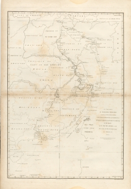
Detail View: Old Maps Collection: A chart, on Mercator's projection, containing the track and soundings of the Lion, the Hindostan and Tenders, from Turon-Bay in Cochin-China to the mouth of the Pei-Ho River in the Gulph of Pe-Tche-Lee or Pekin
|
Barcode:
|
3687800301791A
|
|
Title:
|
A chart, on Mercator's projection, containing the track and soundings of the Lion, the Hindostan and Tenders, from Turon-Bay in Cochin-China to the mouth of the Pei-Ho River in the Gulph of Pe-Tche-Lee or Pekin
|
|
Contributor:
|
Barrow, John, 1764-1848, cartographer
|
|
Contributor:
|
Baker, Benjamin, fl. 1780-1824, engraver
|
|
Contributor:
|
Nicol, George, ca. 1740-1828, publisher
|
|
Category:
|
Thematic Maps
|
|
Type:
|
Printed
|
|
Language:
|
English
|
|
Create Year:
|
1796
|
|
Format:
|
JPEG 6635 × 9522, 57.4MB
|
|
Page No.:
|
4
|
|
Scale:
|
[ca. 1:4,300,000] ; Mercator proj.
|
|
Physical Map Dimension (cm):
|
37 x 26 cm, on sheet 43 x 31 cm
|
|
Note:
|
Detailed nautical chart of the coast of China from Staunton's 'An Authentic Account of an Embassy from the King of Great Britain to the Emperor of China', depicting the routes of the vessels carrying the Earl of Macartney's -an Anglo-Irish diplomat- Embassy along the coast of China with a note of the dates as well as a series of depth soundings. The chart extends from Turon Bay -now a days Da Nang, Vietnam- up the coast of eastern Asia to the Gulph of Leao-Tung in the Yellow Sea. The map includes the area around Hong Kong -unnamed on the map- and Macao, part of Formosa and an extended look at the China coastline. Macartney was accompanied by Staunton in the dispatch to Beijing in 1792, traveling via Madeira, Tenerife, Rio de Janeiro, the Cape of Good Hope and Indonesia. The track of the Lion, Hindostan, and Tenders is traced, with soundings, sea bottom classifications, temperature and barometric readings, dates, and assorted notes -such as Lion and Tenders parted from the Hindostan in the fog. China is divided into several provinces, and many towns and cities are named. A portion of the Great Wall of China is depicted and rivers are accompanied by notes on their courses and sources. Taiwan is depicted with incomplete borders to the east of the ships track. The Chinese coastline is drawn in fine detail, as is the west coast of Korea. The embassy, the first such to China, had two objectives: the first to register with the Emperor, British displeasure at the treatment that the British merchants were receiving from the Chinese, the second to gain permission for a British minister to be resident in China. Diplomatically, the mission was a complete failure, as the Emperor proved entirely unwilling to consider trade concessions. Staunton's work produced some of the earliest accurate maps of the interior of China and provided many invaluable geographical and cultural observations.
|
|
Note:
|
Original is a printed map from the work 'An authentic account of an embassy from the King of Great Britain to the Emperor of China', 70 x 50 cm.
|
|
Note:
|
On the bottom right corner of the map: "Engraved by B. Baker. Islington."
|
|
Note:
|
Depicts the Pekin Meridian.
|
|
Note:
|
Four borders of the map with latitude and longitude lines.
|
|
Note:
|
Relief shown by hachures and bathymetric relief shown by soundings.
|
|
Note:
|
Macao in China maps.
|
|
Reference:
|
Tooley's Dic. of Mapmakers, A-D [vol. 1], p. 90
|
|
Subject:
|
Voyages and travels
|
|
Geographic Area:
|
China
|
|
Relation Note:
|
vol. 2, [pl. 4]
|
|
Pub Title:
|
An authentic account of an embassy from the King of Great Britain to the Emperor of China; including cursory observations made, and information obtained in travelling through that ancient empire, and a small part of Chinese Tartary
|
|
Pub Author:
|
Staunton, George, Sir, 1737-1801
|
|
Pub Year:
|
1797
|
|
Pub location:
|
London
|
|
Provenance:
|
Harvard College Library
|
|
Provenance:
|
http://id.lib.harvard.edu/alma/990035943920203941/catalog
|
|
Provenance Call No.:
|
MAP-LC DS708. S78 pf*
|
|
MUST holding:
|
https://must.primo.exlibrisgroup.com/permalink/853MUST_INST/reglfj/alma991000041499705076
|