Detail View: Old Maps Collection: [Planisphère]
|
Barcode:
|
4687820501092
|
|
Title:
|
[Planisphère]
|
|
Other Title:
|
Carte du Dépôt
|
|
Contributor:
|
Lopes, Sebastião, fl. ca. 1555-1596, cartographer
|
|
Contributor:
|
Lemos, Pedro de, dubious author
|
|
Category:
|
General Maps
|
|
Type:
|
Manuscripts
|
|
Language:
|
Latin
|
|
Language:
|
Portuguese
|
|
Language:
|
Spanish
|
|
Create Year:
|
[ca. 1583]
|
|
Format:
|
JPEG 2000, 13592 x 14391, 22MB
|
|
Page No.:
|
2
|
|
Scale:
|
Scale not given.
|
|
Physical Map Dimension (cm):
|
47 x 89 cm, on sheet 60 x 98 cm
|
|
Note:
|
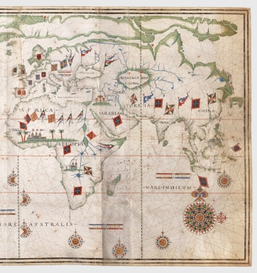
Even though many libraries seem to state Pedro de Lemos as the main author of this chart and place it's making ca. 1590 this was a wrong assumption made after an article on the chart by Albert Krammerer. The undoubtedly author of the map is Sebastião Lopes as all the decorative motifs as the wind roses, the scales and the flags are exact copies from his other works -Chart of 1558, Mediterranean Chart at Greenwich and Atlantic Chart at Vila Viçosa. Although there seems to be doubts about the handwriting it could only mean Sebastião Lopes had the help of an assistant but the map is most certainly by him. The nautical chart is very well defined with two separate land masses -America and Europe with Asia and Africa-, the known and imaginary islands and archipelagos and a fanciful Arctic land all across the upper part of the map. This chart is the earliest known complete representation of the Philippines. On the outer fillet of the left side border there is an unidentified seal twice impressed on sealing-wax that seems to have been affixed before the drawing of the frame was completed.
|
|
Note:
|
Original is a manuscript nautical chart on parchment, 114 x 218 cm. Because the first time it was mentioned by author Henry Harrisse he called it a '[...] carte [...] du dépôt des cartes et plans de la Marine' it became known amongst cartography historians as the 'Carte du Dépôt'.
|
|
Note:
|
Title from provenance library.
|
|
Note:
|
On the map Jerusalem is identified by a Calvary, in Africa is depicted the Elmina Castle -erected by the Portuguese in 1482 as Castelo de São Jorge da Mina- with some palm trees and in Congo there is the drawing of a catholic church, most probably Cathedral of the Holy Saviour of Congo, first a simple church -which would be cathedral in 1596- initiated ca. 1491, under King João I of Portugal.
|
|
Note:
|
On the nautical chart there are 20 compass roses, to which 17 are full and 3 are 3/4 wind roses. The 2 bigger ones on each side of the bottom part of the map are the more ornamented ones with a fleur de lis indicating north and a cross of the Order of Christ indicating east. These are colored red, green, black, blue and yellow. The smaller compass roses either have an arrow or a star indicating north and all have a little cross on the east side. This smaller wind roses are colored red, green, yellow and blue. The rhumb lines for the principal winds are black, green for the half-winds and red for the quarter-winds.
|
|
Note:
|
There are 6 scale lines on the map, 5 horizontal and 1 vertical. They are colored blue, red and yellow.
In the chart are depicted 11 coat of arms and 40 flags. The coat of arms are mostly in Europe and two big ones in Brazil, the first of Spain in the south of South America and the other of Portugal in Brazil. The flags are mostly of Aragon, Castile, Portugal, Arabic, the Order of Christ and even a flag with the 2 Papal keys pointing to Rome.
|
|
Note:
|
There is a latitude line, north of the Equator, between North America and Europe; another one south of the Equator, between Brazil and Africa and a continuous one -on both sides of the Equator- on the right side of the map. There is also the curious oblique latitude line near Terra Nova -just under 'Ter[r]a do Lavrador'- which first appeared in Pedro Reinel's signed chart of ca. 1506, it disappeared in 1550 and reappeared in the 1590 Atlas by Bartolomeu Lasso. All scale lines are colored green and yellow interchangeably.
|
|
Note:
|
Tropic of Cancer, Equator and Tropic of Capricorn drawn in red.
|
|
Note:
|
Land masses are outlined in green and islands are colored either red, blue or yellow. Place names are written in black and red.
|
|
Note:
|
Relief is show pictorially even though very scarse.
|
|
Note:
|
Map outlines in double fillet.
|
|
Note:
|
Macao in World Maps.
|
|
Reference:
|
Cortesão, A. Portugalliae Monumenta Cartographica, vol. IV, p. 17-21
|
|
Reference:
|
Dahlgren, E.W. Les débuts de la Cartographie du Japon, p. 43
|
|
Reference:
|
Harrisse, H. Jean et Sébastien Cabot, p. 238-239
|
|
Reference:
|
Nordenskiöld, A.E. Periplus, p. 159
|
|
Reference:
|
Kammerer, A. La Mer Rouge l'Abyssinie, et l'Arabie aux XVI.e et XVII.e siècles et la Cartographie des Portulans du Monde Orientale; vol. VI, pl. LXXXV, vol. VII, p. 214-218
|
|
Reference:
|
Destombes, M. La mappemonde de Petrus Plancius, p. 14-17
|
|
Reference:
|
Andrews, M.C. Scotland in the portolan charts, The Scottish Gepgraphical Magazine, no. XLII, p. 294
Teleki, P.G. Atlas zur Geschichte der Kartographie der japanischen Inseln, p. 23
|
|
Reference:
|
Gernez, D. Les Cartes avec l'èchelle de latitudes auxiliaire pour la région de Terre-Neuve, vol. I, p. 25-27
|
|
Reference:
|
Randles, W.G.L. South-east Africa on selected printed maps of the sixteenth century, Imago Mundi, vol. XIII, p. 87
|
|
Reference:
|
Randles, W.G.L. South-east Africa and the Empire of Monomotapa as shown on selected printed maps of the 16th century, Studia, vol. 2, p. 158
|
|
Reference:
|
Ruge, S. Die Entdeckungsgeschichte der Neuen Welt
|
|
Subject:
|
Harbors
|
|
Subject:
|
Coasts
|
|
Geographic Area:
|
World
|
|
Provenance:
|
Bibliothèque Nationale de France
|
|
Provenance:
|
https://catalogue.bnf.fr/ark:/12148/cb40592157x
|
|
Provenance Call No.:
|
GE SH ARCH-38
|
|
MUST holding:
|
https://must.primo.exlibrisgroup.com/permalink/853MUST_INST/171sgkf/alma991002923430505076
|