Detail View: Old Maps Collection: Central Atlantic Ocean with the Azores and a blank half sheet
|
Barcode:
|
3687800354645G
|
|
Title:
|
Central Atlantic Ocean with the Azores and a blank half sheet
|
|
Original Title:
|
[Océan Atlantique central avec les Açores et un demi-feuillet vierge]
|
|
Other Title:
|
Atlas Miller
|
|
Other Title:
|
Lopo Homem-Reineis Atlas
|
|
Contributor:
|
Homem, Lopo, fl. 1517-1565, cartographer
|
|
Contributor:
|
Reinel, Pedro, ca. 1464-ca. 1542, cartographer
|
|
Contributor:
|
Reinel, Jorge, ca. 1502-ca. 1572, cartographer
|
|
Contributor:
|
António de Holanda, 1480?-1556, illustrator
|
|
Contributor:
|
Santarém, Manuel Francisco de Barros e Sousa de Mesquita de Macedo Leitão e Carvalhosa, 1791-1856, 2nd viscount of, former owner
|
|
Contributor:
|
Miller, Emmanuel, 1812-1886, former owner
|
|
Category:
|
Sea Charts
|
|
Type:
|
Manuscripts
|
|
Language:
|
Latin
|
|
Language:
|
Portuguese
|
|
Create Year:
|
1519
|
|
Format:
|
JPEG 2000, 14658 × 10608, 23MB
|
|
Page No.:
|
2
|
|
Scale:
|
Scale not given.
|
|
Note:
|
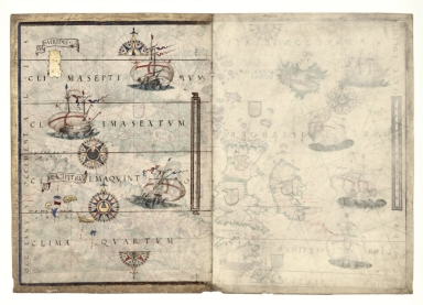
This map is from an Atlas known as Atlas Miller or Lopo Homem-Reineis Atlas. It was a joint work of cartographers Lopo Homem, Pedro Reinel and Jorge Reinel, and illustrated by Flemish miniaturist António de Holanda. It is considered one of the most beautiful Renaissance cartographic documents from Portugal. According to some authors the Atlas formed by 6 sheets is missing a 7th sheet which probably included a map of Africa. The five sheets with the maps were sold by Jacques Charavey -a Paris bookseller- to Portuguese viscount of Santarém that later sold them to Emmanuel Clement Miller, hence the name Miller Atlas. In 1897 Millers widow sold it to the Bibliothèque Nationale de France. The mapamundi sheet was later found in an auction in London in 1930 with the no. 91 in a catalog of Sotheby & Co. The buyer -Marcel Destombes- with the help of experts, concluded in 1939 that belonged to the Miller Atlas and in 1976 donated it to Bibliothèque Nationale de France. The title page bears a later inscription -probably after 1559- with the arms of Catherine de Medici, queen of France. It is thought to have been an offering from King Manuel I of Portugal to Francis I of France. However many authors agree that it had a political ground for it secretly denies the idea that the actual circumnavigation of the globe was possible and it was made to hinder Magellan’s voyage under the Spanish King. The surviving chart that illustrates the Azores is the left half of what was once an entire chart. Besides the Insule Ancipitrum (Azores) and another large rectangular and invented island called 'Insula Viridis', it only has some illuminations of ships and some wind-roses. When complete, this chart would have shown the waters of the Atlantic off the Iberian Peninsula and a part of the peninsula, stretching only slightly further east than Portugal. It was essentially a portolan chart that, despite being decorated, could clearly be used for navigational purposes. The chart also includes four parallels or climate circles, corresponding to Ptolemy’s fourth, fifth, sixth and seventh climates, while the only place-names are those of the islands, which are already both accurate and definitive.
|
|
Note:
|
Original is a manuscript vellum Atlas with 6 sheets with both recto and verso, 42 x 59 cm.
|
|
Note:
|
Title from provenance library.
|
|
Note:
|
The map three sail ships all Portuguese, each one of them with the cross of the Order of Christ on their sails. There are two full and two half 32-point compass roses, three with an arrow indicating north and another the arrow is pointing south. All colored red, blue and gold with rhumb lines of the principal winds in black, half-winds in green and quarter-winds in red.
|
|
Note:
|
Table of leagues is vertical on the right side of the map inside a gold cartouche.
|
|
Note:
|
Place names in minuscule written in red.
|
|
Note:
|
Islands colored red, blue and gold.
|
|
Note:
|
The map is mainly in Latin but the place names are in Portuguese.
|
|
Note:
|
Map is outlined in red and blue fillet with a wide gold border.
|
|
Reference:
|
Cortesão, A. Portugaliae Monumenta Cartographica, vol. 1. p. 55-61
|
|
Reference:
|
La Mappemonde Lopo Homem et L'atlas Miller, The Geographical Journal, vol. 94, no. 6, p. 485-492
|
|
Reference:
|
Miró, M. Atlas Miller, p. [272]-[283]
|
|
Reference:
|
龚缨晏. 《米勒之地图集》之谜, 地图, 02期
|
|
Reference:
|
Marques, A.P. Os Descobrimentos e o 'Atlas Miller
|
|
Reference:
|
Denucé, J. Les origines de la cartographie portugaise et les cartes des Reinel
|
|
Reference:
|
Pastoureau, M. Sur la route des deux Indes http://expositions.bnf.fr/marine/arret/03-2-2.htm
|
|
Subject:
|
Atlantic Ocean -- Maps
|
|
Geographic Area:
|
Atlantic Ocean
|
|
Geographic Area:
|
Azores
|
|
Relation Note:
|
[Sheet 2 verso]
|
|
Pub Title:
|
[Atlas nautique du Monde, dit Atlas Miller]
|
|
Pub Author:
|
Homem, Lopo, fl. 1517-1565.
|
|
Pub Year:
|
1519
|
|
Pub location:
|
[S.l.]
|
|
Provenance:
|
Bibliothèque Nationale de France
|
|
Provenance:
|
https://catalogue.bnf.fr/ark:/12148/cb40887480s
|
|
Provenance Call No.:
|
GE DD-683 (2 RES)
|
|
MUST holding:
|
https://must.primo.exlibrisgroup.com/permalink/853MUST_INST/reglfj/alma991003027349705076
|