Detail View: Old Maps Collection: Northeast Atlantic Ocean and Northern Europe
|
Barcode:
|
4687820501089
|
|
Title:
|
Northeast Atlantic Ocean and Northern Europe
|
|
Original Title:
|
[Océan Atlantique Nord-Est et Europe du Nord]
|
|
Other Title:
|
Atlas Miller
|
|
Other Title:
|
Lopo Homem-Reineis Atlas
|
|
Contributor:
|
Homem, Lopo, fl. 1517-1565, cartographer
|
|
Contributor:
|
Reinel, Pedro, ca. 1464-ca. 1542, cartographer
|
|
Contributor:
|
Reinel, Jorge, ca. 1502-ca. 1572, cartographer
|
|
Contributor:
|
António de Holanda, 1480?-1556, illustrator
|
|
Contributor:
|
Santarém, Manuel Francisco de Barros e Sousa de Mesquita de Macedo Leitão e Carvalhosa, 1791-1856, 2nd viscount of, former owner
|
|
Contributor:
|
Miller, Emmanuel, 1812-1886, former owner
|
|
Category:
|
Sea Charts
|
|
Type:
|
Manuscripts
|
|
Language:
|
Portuguese
|
|
Language:
|
Latin
|
|
Create Year:
|
1519
|
|
Format:
|
JPEG 2000, 14472 × 10384, 22MB
|
|
Page No.:
|
2
|
|
Scale:
|
Scale not given.
|
|
Physical Map Dimension (cm):
|
41 x 60 cm, on sheet 52 x 68 cm
|
|
Note:
|
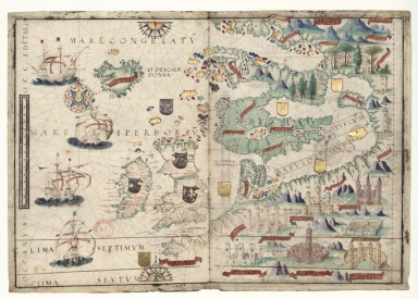
This map is from an Atlas known as Atlas Miller or Lopo Homem-Reineis Atlas. It was a joint work of cartographers Lopo Homem, Pedro Reinel and Jorge Reinel, and illustrated by Flemish miniaturist António de Holanda. It is considered one of the most beautiful Renaissance cartographic documents from Portugal. According to some authors the Atlas formed by 6 sheets is missing a 7th sheet which probably included a map of Africa. The five sheets with the maps were sold by Jacques Charavey -a Paris bookseller- to Portuguese viscount of Santarém that later sold them to Emmanuel Clement Miller, hence the name Miller Atlas. In 1897 Millers widow sold it to the Bibliothèque Nationale de France. The mapamundi sheet was later found in an auction in London in 1930 with the no. 91 in a catalog of Sotheby & Co. The buyer -Marcel Destombes- with the help of experts, concluded in 1939 that belonged to the Miller Atlas and in 1976 donated it to Bibliothèque Nationale de France. The title page bears a later inscription -probably after 1559- with the arms of Catherine de Medici, queen of France. It is thought to have been an offering from King Manuel I of Portugal to Francis I of France. However many authors agree that it had a political ground for it secretly denies the idea that the actual circumnavigation of the globe was possible and it was made to hinder Magellan’s voyage under the Spanish King. This chart depicts Northwest Europe covering the area from Britain and Ireland to the furthest reaches of the Baltic, and from the Iceland Sea to the border regions between France, Flanders and Germany.
|
|
Note:
|
Original is a manuscript vellum Atlas with 6 sheets with both recto and verso, 42 x 59 cm.
|
|
Note:
|
Title from provenance library.
|
|
Note:
|
There are nine heraldic devices on the map, two British, one Scott and six German; there are also nine castles or towers identifying important places. The map has four sail ships all Portuguese, each one of them with the cross of the Order of Christ on their sails. There are one full and two half 32-point compass roses, two with an arrow indicating north. All colored red, blue and gold with rhumb lines of the principal winds in black, half-winds in green and quarter-winds in red.
|
|
Note:
|
Table of leagues is vertical on the left side of the map inside a gold cartouche.
|
|
Note:
|
Relief shown pictorially.
|
|
Note:
|
Place names in minuscule written in red and black.
|
|
Note:
|
Landmasses outlined or colored green with islands colored red, blue and gold.
|
|
Note:
|
The map is mainly in Latin but the place names are in Portuguese.
|
|
Note:
|
Map is outlined in simple fillet.
|
|
Reference:
|
Cortesão, A. Portugaliae Monumenta Cartographica, vol. 1. p. 55-61
|
|
Reference:
|
Foncin, M. Catalogue des cartes nautiques sur vélin conservées au Département des cartes et plans, 23
|
|
Reference:
|
La Mappemonde Lopo Homem et L'atlas Miller, The Geographical Journal, vol. 94, no. 6, p. 485-492
|
|
Reference:
|
Miró, M. Atlas Miller, p. [272]-[283]
|
|
Reference:
|
龚缨晏. 《米勒之地图集》之谜, 地图, 02期
|
|
Reference:
|
Marques, A.P. Os Descobrimentos e o 'Atlas Miller
|
|
Reference:
|
Denucé, J. Les origines de la cartographie portugaise et les cartes des Reinel
|
|
Reference:
|
Pastoureau, M. Sur la route des deux Indes http://expositions.bnf.fr/marine/arret/03-2-2.htm
|
|
Subject:
|
Europe -- Maps
|
|
Geographic Area:
|
Europe
|
|
Geographic Area:
|
North Atlantic Ocean
|
|
Relation Note:
|
[Sheet 2 reto]
|
|
Pub Title:
|
[Atlas nautique du Monde, dit Atlas Miller]
|
|
Pub Author:
|
Homem, Lopo, fl. 1517-1565
|
|
Pub Year:
|
1519
|
|
Pub location:
|
[S.l.]
|
|
Provenance:
|
Bibliothèque Nationale de France
|
|
Provenance:
|
https://catalogue.bnf.fr/ark:/12148/cb40887480s
|
|
Provenance Call No.:
|
GE DD-683 (2 RES)
|
|
MUST holding:
|
https://must.primo.exlibrisgroup.com/permalink/853MUST_INST/171sgkf/alma991003028849805076
|