Detail View: Old Maps Collection: China, Costa de Leste. Macau com as ilhas e costas adjacentes
|
Barcode:
|
4687820501086
|
|
Title:
|
China, Costa de Leste. Macau com as ilhas e costas adjacentes
|
|
Other Title:
|
Macau com as ilhas e costas adjacentes
|
|
Other Title:
|
[Praia Grande]
|
|
Other Title:
|
Guia Farol.
|
|
Other Title:
|
Macau, 1866.
|
|
Contributor:
|
Read, W.A., fl. 18--, cartographer
|
|
Contributor:
|
Palha, João Fradique de Moura, 1829-1908, engraver
|
|
Category:
|
Topographic Maps
|
|
Type:
|
Printed
|
|
Language:
|
Portuguese
|
|
Create Year:
|
1865-1866
|
|
Format:
|
JPEG 2000, 14809 x 15251, 32MB
|
|
Scale:
|
[ca. 1:8,000].
|
|
Physical Map Dimension (cm):
|
104 x 112 cm, on sheet 101 x 110 cm
|
|
Note:
|
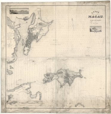
This is a very large chart of Macau and its surroundings, the Green Island and Taipa and part of Lapa or Priest's Island, Macarira or D. João and Coloane. An extensive number of soundings is given, covering practically the whole area of the map, the same is true to inset 3. The map is not only detailed on the water area but also inland, be it by the relief or by the identification of places and buildings. On the Macau Peninsula the architecture appear geometrically stylized, typical of a plan, but all forts are identified as are the most important buildings on the legend on the right bottom corner of the map. The legends on the Lapa Island are mostly about relief and tides.
|
|
Note:
|
Inset 1: [Praia Grande]. - Scale not given. - 6 x 19 cm. -- Inset 2: Guia Farol. - Scale not given. - 6 x 12 cm. -- Inset 3: Macau, 1866. - Scale indeterminable. - 13 x 13 cm.
|
|
Note:
|
Original is a lithograph is four sheets, mounted 113 x 1180 cm.
|
|
Note:
|
On the bottom left corner of the map: "J.F.M. Palha gr."
|
|
Note:
|
On the map there are three insets with two of them being of views os Macau. One is the view of the Inner Harbor and the other is a close up view of the Guia Fort and Lighthouse with a Chinese junk near by.
|
|
Note:
|
There is a 32-point compass rose on the map with a star indicating north.
|
|
Note:
|
Double scale line on the bottom part of the map, right to inset 3.
|
|
Note:
|
Relief shown by form lines, spot heights and land forms. Bathymetric relief by soundings and isolines.
|
|
Note:
|
Map outlined in triple fillet with insets 1 and 2 outlined in double fillet and inset 3 in simple fillet.
|
|
Note:
|
Macao and its surroundings.
|
|
Note:
|
City plans of Macao.
|
|
Note:
|
Images of Macao.
|
|
Subject:
|
Macao (China) -- Maps
|
|
Geographic Area:
|
Macao (China)
|
|
Provenance:
|
Bibliothèque Nationale de France
|
|
Provenance:
|
https://catalogue.bnf.fr/ark:/12148/cb406445100
|
|
Provenance Call No.:
|
GE C-9481
|
|
MUST holding:
|
https://must.primo.exlibrisgroup.com/permalink/853MUST_INST/171sgkf/alma991002988849405076
|