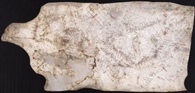
Detail View: Old Maps Collection: Nautical chart of the Eastern Atlantic Ocean, the Mediterranean Sea and part of the Black Sea, known as Carta Pisana
|
Barcode:
|
3687800354655H
|
|
Title:
|
Nautical chart of the Eastern Atlantic Ocean, the Mediterranean Sea and part of the Black Sea, known as Carta Pisana
|
|
Original Title:
|
[Carte marine de l'océan Atlantique Est, de la mer Méditerranée et d'une partie de la mer Noire, connue sous le nom de Carte Pisane]
|
|
Other Title:
|
Carta Pisana
|
|
Other Title:
|
Carte Pisane
|
|
Category:
|
Early Old Maps
|
|
Type:
|
Manuscripts
|
|
Language:
|
Latin
|
|
Create Year:
|
[1275]-[1300]
|
|
Format:
|
JPEG 2000, 16842 × 8069, 19MB
|
|
Scale:
|
Scale not given.
|
|
Physical Map Dimension (cm):
|
50 x 104 cm, on sheet 59 x 111 cm
|
|
Note:
|
This chart is of Italian, Pisan or Genoese origin and like most of Italian charts only depicts the Mediterranean Sea and the Black Sea. The Mediterranean is portrayed inside two circles, one for the western Mediterranean, one for the eastern. These circles are divided into sixteen parts, providing the map with sixteen corresponding wind directions inside double fillet cartouches in red.Britain and the north coast of Europe is sketchy, lacks detail and the numbers of toponyms is much lower than that of the Mediterranean. A very important predicate of this chart is its extraordinary accuracy and detail, particularly when compared with the religion-inspired cartography of the time. It is the oldest surviving nautical chart and the first known chart to have a graphical scale located inside a double line circle on the extension of the parchment. Carta Pisana is believed to be the result of a long period of development.
|
|
Note:
|
Original is a manuscript on parchment, 48 x 103 cm.
|
|
Note:
|
Title from provenance library.
|
|
Note:
|
Table of leagues in red inside a double line circle on the extension of the parchment of the right border of the map.
|
|
Note:
|
Place names in minuscule written in red and black.
|
|
Reference:
|
Foncin, M. Catalogue des cartes nautiques sur vélin conservées au Département des cartes et plans, 1
|
|
Reference:
|
Brentjes, S. Medieval Portolan Charts as Documents of Shared Cultural Spaces, In Acteurs des transferts culturels en Méditerranée médiévale, p. 135-146
|
|
Reference:
|
Pflederer, R. Census of Portolan Charts & Atlases: as reported and listed by the noted scholars of the genre in their works ranging from 1897 to 2008, p. 44
|
|
Subject:
|
Nautical Charts
|
|
Geographic Area:
|
Europe
|
|
Geographic Area:
|
Africa
|
|
Geographic Area:
|
Mediterranean Sea
|
|
Geographic Area:
|
Black Sea
|
|
Provenance:
|
Bibliothèque Nationale de France
|
|
Provenance:
|
https://catalogue.bnf.fr/ark:/12148/cb406673515
|
|
Provenance Call No.:
|
GE B-1118 (RES)
|
|
MUST holding:
|
https://must.primo.exlibrisgroup.com/permalink/853MUST_INST/171sgkf/alma991003032049705076
|