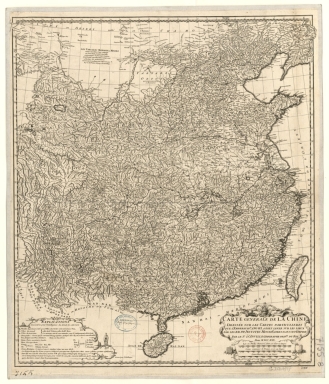
Detail View: Old Maps Collection: Carte generale de la Chine : dressée sur les cartes particulieres que l'Empereur Cang-hi a fait lever sur les lieux par les RR. PP. Jesuites mission[n]aires dans cet Empire
|
Barcode:
|
4687820501078
|
|
Title:
|
Carte generale de la Chine : dressée sur les cartes particulieres que l'Empereur Cang-hi a fait lever sur les lieux par les RR. PP. Jesuites mission[n]aires dans cet Empire
|
|
Contributor:
|
Anville, Jean Baptiste Bourguignon d', 1697-1782, cartographer
|
|
Contributor:
|
Gravelot, Hubert-François, 1699-1773, illustrator, engraver
|
|
Contributor:
|
Delahaye, Jean Baptiste, fl. 1721-1723, engraver
|
|
Category:
|
General Maps
|
|
Type:
|
Printed
|
|
Language:
|
French
|
|
Create Year:
|
1730
|
|
Format:
|
JPEG 2000, 6600 x 7704, 10MB
|
|
Page No.:
|
219
|
|
Scale:
|
[1:5,000,000].
|
|
Physical Map Dimension (cm):
|
59 x 51 cm, on sheet 72 x 62 cm
|
|
Note:
|
The sources of the map were Jesuit missionaries commissioned by Emperor Kangxi (1654-1722), who between 1708 and 1716 surveyed China. With these surveys it was printed in 1719 a woodblock Chinese Atlas '康熙皇輿全覽圖'. A copperplate edition was later requested by the Emperor to Matteo Ripa (1682-1746) and the copper plates exist to this day. The map includes China with Taiwan and Hainan. The explanation on the left bottom corner gives some information necessary for the understanding of the chart. Most information is about the Chinese and Portuguese language references on the map.
|
|
Note:
|
Original is a copperplate printed, from Chinese originals, 90 x 56 cm.
|
|
Note:
|
Under the title cartouche: "Gravelot inv. et fec." On the right side on the legend cartouche: "Gravé par Delahaye."
|
|
Note:
|
Ornamented scrollwork cartouche with a mandarin head on the top sided by dragons.
|
|
Note:
|
Triple scale line in Chinese lys, leagues and nautic leagues, in black and white interchangeably, underneath the title cartouche on the right bottom corner of the map.
|
|
Note:
|
Relief shown pictorially.
|
|
Note:
|
Map with graticule.
|
|
Note:
|
The four borders of the map with latitude and longitude lines in black and white interchangeably.
|
|
Note:
|
Map outlined in double fillet.
|
|
Note:
|
Macao in China maps.
|
|
Subject:
|
China -- Maps
|
|
Geographic Area:
|
China
|
|
Geographic Area:
|
Taiwan
|
|
Geographic Area:
|
Hainan Sheng (China)
|
|
Relation Note:
|
Vol. 3, p. 219
|
|
Pub Title:
|
Nouvel Atlas de la Chine, de la Tartarie chinoise, et du Thibet.
|
|
Pub Author:
|
Anville, Jean-Baptiste Bourguignon d', 1697-1782
|
|
Pub Year:
|
1737
|
|
Pub location:
|
The Hague
|
|
Provenance:
|
Bibliothèque Nationale de France
|
|
Provenance:
|
https://catalogue.bnf.fr/ark:/12148/cb40606537p
|
|
Provenance Call No.:
|
GE DD-2987 (7155 B)
|
|
MUST holding:
|
https://must.primo.exlibrisgroup.com/permalink/853MUST_INST/171sgkf/alma991002988049305076
|