Detail View: Old Maps Collection: Nautical chart of the Mediterranean Sea and the Black Sea
|
Barcode:
|
3687800354662F
|
|
Title:
|
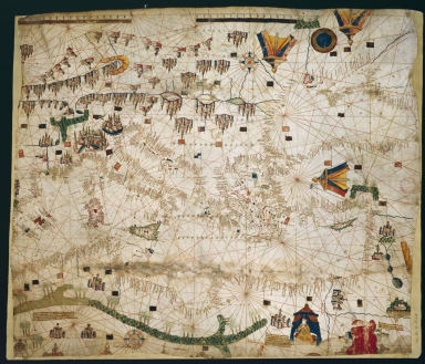
Nautical chart of the Mediterranean Sea and the Black Sea
|
|
Original Title:
|
[Carte marine de la mer Méditerranée et de la mer Noire]
|
|
Contributor:
|
Roselli, Pietro, fl. 1446-1489, cartographer
|
|
Category:
|
Sea Charts
|
|
Type:
|
Manuscripts
|
|
Language:
|
Catalan
|
|
Create Year:
|
[ca. 1466]
|
|
Format:
|
JPEG 2000, 8942 × 7678, 11MB
|
|
Scale:
|
Scale not given.
|
|
Note:
|
Pietro Roselli is believed to be a Catalan cartographer and hydrographer working in Italy. This chart depicts Central and Eastern Mediterranean from the Balearic Islands to the Asian coastline of the Mediterranean and northern Red Sea. On land are displayed rivers with tributaries, Jordan lakes, Danube islands. he map has been cut off a fragment on the left edge and cropped on the right and bottom, was found in the binding of notarial deeds kept in the Archives départementales du Vaucluse who donated it to BNF on October 10th, 1938.
|
|
Note:
|
Original is a manuscript nautical chart on parchment, 61 x 71 cm.
|
|
Note:
|
Title from provenance library.
|
|
Note:
|
There are two 32-point compass roses with an arrow indicating north, colored red and blue. The rhumb lines for the principal winds are in black, half-winds in green and quarter-winds in red. Quite a number of castles and tents are scattered on the chart representing cities with special highlight given to the Italian city of Genoa. In Africa can be see palm tress, a camel and an elephant. The Red Sea on the right bottom corner is colored red.
|
|
Note:
|
There are two table of leagues on the map, one colored red and the other blue.
|
|
Note:
|
Relief shown pictorially, with depictions of mountains typical of Catalan maps.
|
|
Note:
|
Bigger islands outlined in green and magenta and smaller islands colored green, red and blue.
|
|
Note:
|
Place names written in red and black.
|
|
Reference:
|
Foncin, M. Catalogue des cartes nautiques sur vélin conservées au Département des cartes et plans, 16
|
|
Reference:
|
Pflederer, R. Census of Portolan Charts & Atlases: as reported and listed by the noted scholars of the genre in their works ranging from 1897 to 2008, p. 49
|
|
Subject:
|
Mediterranean -- Maps
|
|
Geographic Area:
|
Mediterranean Sea
|
|
Geographic Area:
|
Portugal
|
|
Geographic Area:
|
Spain
|
|
Geographic Area:
|
Italy
|
|
Geographic Area:
|
Croatia
|
|
Geographic Area:
|
Greece
|
|
Geographic Area:
|
Turkey
|
|
Geographic Area:
|
Africa
|
|
Provenance:
|
Bibliothèque Nationale de France
|
|
Provenance:
|
https://catalogue.bnf.fr/ark:/12148/cb40670293b
|
|
Provenance Call No.:
|
GE C-15118 (RES)
|
|
MUST holding:
|
https://must.primo.exlibrisgroup.com/permalink/853MUST_INST/171sgkf/alma991003031248905076
|