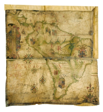
Detail View: Old Maps Collection: Fragment of a nautical chart showing the coasts of Central and South America on the Atlantic and Pacific Ocean
|
Barcode:
|
3687800354656I
|
|
Title:
|
Fragment of a nautical chart showing the coasts of Central and South America on the Atlantic and Pacific Ocean
|
|
Original Title:
|
[Fragment d'une carte nautique représentant les côtes de l'Amérique centrale et de l'Amérique du sud sur l'Océan Atlantique et sur l'Océan Pacifique, 159-]
|
|
Contributor:
|
Teixeira, Luís, 1564-1604, cartographer
|
|
Category:
|
Sea Charts
|
|
Type:
|
Manuscripts
|
|
Language:
|
Portuguese
|
|
Create Year:
|
[ca. 1590]
|
|
Format:
|
JPEG 2000, 8987 × 9794, 12MB
|
|
Scale:
|
Scale not given.
|
|
Physical Map Dimension (cm):
|
52 x 50 cm, on sheet 62 x 58 cm
|
|
Note:
|
This is part of a chart that was cut to be used as a binding for notarial records. The complete chart constituted an Atlantic chart very common at that time. The re-use of parchment sheets, particularly of maps and music notes, for other purposes was very common either for decorative or simple for economic purposes. Although, the signature of João Baptista Lavanha (ca. 1550-1624) figures on the left bottom corner of the map it seems that the author is in fact Luís Teixeira when compared to other works by him.
|
|
Note:
|
Original is a fragment of a manuscript nautical chart in parchment, 52 x 52 cm.
|
|
Note:
|
Title from provenance library.
|
|
Note:
|
There are six full 32-point compass roses on the represented and two half compasses roses; three have a fleur-de-lis indicating north and the others an arrow. All of them are colored red, blue, green and gold with rhumb lines for the principal winds in black, half-winds in green and quarter-winds in red. There are five coats of arms on the continent, a Portuguese crowned one in Brazil, and three Spanish with another one unidentified; three Spanish flags appear in the area of Colombia and Venezuela. A sail ship can spotted on the Atlantic Ocean on the upper right corner of the fragment.
|
|
Note:
|
Vertical table of leagues inside strapwork cartouche on the left border of the map, headed by the emblem of the Society of Jesus "IHS". Part of another table of leagues can be seen on the right margin of the map with top and bottom borders colored green and red.
|
|
Note:
|
Relief shown pictorially.
|
|
Note:
|
Land masses outlined in green with islands colored red, green, blue and gold. Toponyms in red and black.
|
|
Note:
|
Lines of the Equator and Tropic of Capricorn in red.
|
|
Note:
|
Outlined with red border on the left and bottom margins.
|
|
Reference:
|
Cortesão, A. Portugalliae Monumenta Cartographica, vol. 3, p. 77-78
|
|
Reference:
|
Pflederer, R.L. Catalogue of the Portolan Charts and Atlases in the Library of Congress, p. 52
|
|
Reference:
|
Foncin, M. Catalogue des cartes nautiques sur vélin conservées au Département des cartes et plans, p. 41-42
|
|
Subject:
|
America -- Maps
|
|
Geographic Area:
|
America
|
|
Geographic Area:
|
South America
|
|
Geographic Area:
|
Central America
|
|
Geographic Area:
|
Pacific Ocean
|
|
Geographic Area:
|
Atlantic Ocean
|
|
Provenance:
|
Bibliothèque Nationale de France
|
|
Provenance:
|
https://catalogue.bnf.fr/ark:/12148/cb40595560n
|
|
Provenance Call No.:
|
GE D-20353 (RES)
|
|
MUST holding:
|
https://must.primo.exlibrisgroup.com/permalink/853MUST_INST/171sgkf/alma991003032549805076
|