Detail View: Old Maps Collection: Carte marine de la mer Baltique, de la mer du Nord, de l'océan Atlantique Est, de la mer Méditerranée, de la mer Noire et de la mer Rouge
|
Barcode:
|
3687800354675J
|
|
Title:
|
Carte marine de la mer Baltique, de la mer du Nord, de l'océan Atlantique Est, de la mer Méditerranée, de la mer Noire et de la mer Rouge
|
|
Original Title:
|
[Carte marine de la mer Baltique, de la mer du Nord, de l'océan Atlantique Est, de la mer Méditerranée, de la mer Noire et de la mer Rouge]
|
|
Contributor:
|
Dulcert, Angelino, 1350-1400, cartographer
|
|
Category:
|
Sea Charts
|
|
Type:
|
Manuscripts
|
|
Language:
|
Latin
|
|
Language:
|
Spanish
|
|
Create Year:
|
1339
|
|
Format:
|
JPEG 16368 × 12191, 30MB
|
|
Scale:
|
Scale not given.
|
|
Physical Map Dimension (cm):
|
73 x 102 cm, on sheet 87 x 111 cm
|
|
Note:
|
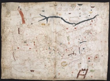
Angelino Dulcert, probably the same person known as Angelino de Dalorto and whose real name was probably Angelino de Dulceto or Dulceti or even Angelí Dolcet, was an Italian-Majorcan cartographer. It is believed he was an Italian of Liguria, trained in Genoa who emigrated to Majorca some time in the 1320's or 1330's. Made in Palma, the chart is considered the founding piece of the Majorcan cartographic school and is notable for giving the first modern depiction of the island of Lanzarote, one of the Canary Islands, as 'Insula de Lanzarotus Marocelus', a reference to the Genoese navigator Lancelotto Malocello, and affixes a Genoese shield to mark the island, a custom retained by future mapmakers. Dulcert also introduces what seems like the Portuguese Madeira islands, named here as 'Capraria' and 'Canaria'. Also on this chart there is oldest known heraldic representation connected with Macedonia as a banner of Skopje, a double-headed eagle Gules above the name of the city of 'Scopi' is written 'Servia' (Serbia).
|
|
Note:
|
Original is a manuscript chart on two parchment sheets, 75 x 102 cm.
|
|
Note:
|
Title from provenance library.
|
|
Note:
|
On the chart are depicted a large number of castles and flags, mountain ranges, rivers and fauna with an elephant, ostrich, exotic birds and a came in Africa. Portraits of monarchs are also present. The Atlas Mountains are colored blue and the Red Sea is red. Roughly at the center there is a gold star in a blue circle in the upper part and a silver half-moon at the bottom.
|
|
Note:
|
There are six table of leagues inside white and green borders, one of them is vertical.
|
|
Note:
|
Relief shown pictorially.
|
|
Note:
|
Place names in minuscule written in red and black.
|
|
Note:
|
Authorship and legends in Latin with place names in Spanish.
|
|
Reference:
|
Foncin, M. Catalogue des cartes nautiques sur vélin conservées au Département des cartes et plans, 3
|
|
Reference:
|
Destombes, M. Cartes hollandaises : la cartographie de la Compagnie des Indes Orientales, 1593-1743, p. 50-52
|
|
Reference:
|
Pflederer, R. Census of Portolan Charts & Atlases: as reported and listed by the noted scholars of the genre in their works ranging from 1897 to 2008, p. 48
|
|
Subject:
|
Nautical charts
|
|
Geographic Area:
|
Mediterranean Sea
|
|
Geographic Area:
|
Europe
|
|
Geographic Area:
|
North Africa
|
|
Geographic Area:
|
Portugal
|
|
Geographic Area:
|
Spain
|
|
Geographic Area:
|
Italy
|
|
Geographic Area:
|
France
|
|
Geographic Area:
|
Germany
|
|
Provenance:
|
Bibliothèque Nationale de France
|
|
Provenance:
|
https://catalogue.bnf.fr/ark:/12148/cb40667403k
|
|
Provenance Call No.:
|
GE B-696 (RES)
|
|
MUST holding:
|
https://must.primo.exlibrisgroup.com/permalink/853MUST_INST/171sgkf/alma991003071549805076
|