Detail View: Old Maps Collection: Nautical chart of the Eastern Atlantic Ocean, Mediterranean Sea, Black Sea and Red Sea
|
Barcode:
|
4687820501068
|
|
Title:
|
Nautical chart of the Eastern Atlantic Ocean, Mediterranean Sea, Black Sea and Red Sea
|
|
Original Title:
|
[Carte marine de l'océan Atlantique Est, de la mer Méditerranée, de la mer Noire et de la mer Rouge]
|
|
Contributor:
|
Soler, Guillem, fl.1380-1385, cartographer
|
|
Category:
|
Sea Charts
|
|
Type:
|
Manuscripts
|
|
Language:
|
Latin
|
|
Language:
|
Spanish
|
|
Create Year:
|
[ca. 1380]
|
|
Format:
|
JPEG 2000, 16908 × 10882, 27MB
|
|
Scale:
|
Scale not given.
|
|
Physical Map Dimension (cm):
|
64 x 104 cm, on sheet 74 x 111 cm
|
|
Note:
|
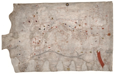
Little is known of Guillem Soler except that he was a Majorcan cartographer of the 14th century. Documents establish his existence in Majorca in 1368, and that he was dead before 1402. He was once thought to be an Italian cartographer working in Majorca, however he was later identified as a citizen of Majorca, probably of Catalan origin, master instrument-maker and mapmaker. He was one of the few non-Jews of the Majorcan cartographic school. The current chart covers the usual range (Mediterranean, Black Sea, Atlantic coast) of the time, but contains some stylistic differences. It is considered typical of the Majorcan school, geared to geographical depiction, with plenty of illustrations and inland details and is one of the first depictions of the royal arms of England as quartered with the royal arms of France, representing the English claims to the French throne in the 14th century. The chart was surely not intended for navigation but to be added to a collection associated with the sea in some merchant’s house.
|
|
Note:
|
Original is a manuscript chart on parchment, 65 x 102 cm.
|
|
Note:
|
Title from provenance library.
|
|
Note:
|
There are four coats of arms on the chart and 69 flags, some in hoisted in castles. The Atlas Mountains are colored blue and the Red Sea is red. Roughly at the center there is a gold star in a blue circle in the upper part, a faced silver half-moon at the bottom and a red sun on a red circle on the right border. The winds are written with a capital red letter inside blue circles.
|
|
Note:
|
Three table of leagues in red, one at the upper center of the chart and part of another on the bottom right corner. A vertical one can be seen on the left border of the chart.
|
|
Note:
|
Relief shown pictorially.
|
|
Note:
|
Small islands colored red, blue and gold.
|
|
Note:
|
Place names in minuscule written in red and black.
|
|
Note:
|
Authorship and legends in Latin with place names in Spanish.
|
|
Reference:
|
Foncin, M. Catalogue des cartes nautiques sur vélin conservées au Département des cartes et plans, 4
|
|
Reference:
|
Cortesão, A. History of Portuguese cartography, p. 49
|
|
Reference:
|
Michienzi and Vagnon, Commissioning and Use of Charts Made in Majorcac.1400: New Evidence from a Tuscan Merchant’sArchive, Imago Mundi, 71:1, pp. 22-33
|
|
Reference:
|
Destombes, M. Cartes hollandaises : la cartographie de la Compagnie des Indes Orientales, 1593-1743, p. 58
|
|
Reference:
|
Pflederer, R. Census of Portolan Charts & Atlases: as reported and listed by the noted scholars of the genre in their works ranging from 1897 to 2008, p. 45
|
|
Subject:
|
Nautical Chart
|
|
Geographic Area:
|
Mediterranean Sea
|
|
Geographic Area:
|
Europe
|
|
Geographic Area:
|
North Africa
|
|
Geographic Area:
|
Portugal
|
|
Geographic Area:
|
Spain
|
|
Geographic Area:
|
France
|
|
Geographic Area:
|
Italy
|
|
Geographic Area:
|
Germany
|
|
Provenance:
|
Bibliothèque Nationale de France
|
|
Provenance Call No.:
|
GE B-1131 (RES)
|
|
MUST holding:
|
https://must.primo.exlibrisgroup.com/permalink/853MUST_INST/171sgkf/alma991003071748105076
|