Detail View: Old Maps Collection: China Sea
|
Barcode:
|
3687800354560C
|
|
Title:
|
China Sea
|
|
Original Title:
|
[Mer de Chine]
|
|
Contributor:
|
Blaeu, Joan, 1596-1673, cartographer
|
|
Category:
|
Sea Charts
|
|
Type:
|
Manuscripts
|
|
Language:
|
Dutch
|
|
Language:
|
Latin
|
|
Language:
|
Portuguese
|
|
Language:
|
Spanish
|
|
Create Year:
|
1667
|
|
Scale:
|
Scale not given ; (E 117°-135° / N 35°40'-20°30').
|
|
Physical Map Dimension (cm):
|
101 x 84 cm, on sheet 111 x 97 cm
|
|
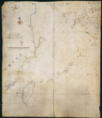
Note:
|
Joan Blaeu succeeded his father, in 1638, as a Verenigde Oostindische Compagnie (VOC) mapmaker and achieved great profit from this office. His principal interest was his major cartographic works on Asia. This is a nautical chart of part of the Southeast coast of China with the Island of Taiwan (Formosa), the Kyushu islands and part of Honshu. Korea can be seen as a very small island. Characteristic of nautical charts the map focus on waterways and inshore areas, and so quite a number of soundings is given as well as some inshore toponyms while the interior remains mostly blank. The soundings are especially concentrated on the Taiwan Strait and around the Penghu islands as the east coast of Taiwan remains mostly blank, the same is true for toponyms on the island.
|
|
Note:
|
Original is a manuscript map on parchment, 100 x 85 cm.
|
|
Note:
|
Title from provenance library.
|
|
Note:
|
There is a 32-point compass rose with a fleur-de-lis indicating north and a cross on the east point, colored blue, red, green and yellow. The rhumb lines for the principal winds are in black, for the half-winds in green and for the quarter-winds in red.
|
|
Note:
|
Double scale line one in red and blue interchangeably and the other in magenta, green and yellow.
|
|
Note:
|
Relief shown pictorially and bathymetric relief by soundings.
The coast lines of continents and bigger islands are outlined in yellow, green and magenta with smaller islands painted in the same colors.
|
|
Note:
|
Latitude line roughly on the middle of the chart in magenta, green and yellow interchangeably.
|
|
Note:
|
Tropic of Cancer in red.
|
|
Note:
|
Toponyms on land in black and toponyms on water in red.
|
|
Note:
|
Author information and table of leagues in Dutch with Tropic of Cancer and Equator in Latin. Place names in Dutch, Spanish and Portuguese.
|
|
Subject:
|
China -- Maps
|
|
Geographic Area:
|
China
|
|
Geographic Area:
|
China Sea
|
|
Geographic Area:
|
Taiwan
|
|
Geographic Area:
|
Japan
|
|
Geographic Area:
|
Korea
|
|
Provenance:
|
Bibliothèque Nationale de France
|
|
Provenance:
|
https://catalogue.bnf.fr/ark:/12148/cb40781794p
|
|
Provenance Call No.:
|
GE SH 18 PF 179 DIV 3 P 1 RES
|
|
MUST holding:
|
https://must.primo.exlibrisgroup.com/permalink/853MUST_INST/171sgkf/alma991003009248505076
|