Detail View: Old Maps Collection: [Mappemonde]

|
Barcode:
|
4687820501062
|
|
Title:
|
[Mappemonde]
|
|
Other Title:
|
[Carte générale]
|
|
Other Title:
|
[Carte du monde]
|
|
Other Title:
|
Worl map
|
|
Contributor:
|
Ptolemy, ca. 90-ca. 168, author
|
|
Contributor:
|
Jan van Kriekenborch, fl. ca. 1485-1514, cartographer, illuminator
|
|
Contributor:
|
D'Angelo, Jacopo, $$d ca. 1360-ca. 1410, translator
|
|
Category:
|
Sea Charts
|
|
Type:
|
Manuscripts
|
|
Language:
|
Latin
|
|
Create Year:
|
1485
|
|
Format:
|
JPEG2000, 9591 × 7012, 11MB
|
|
Scale:
|
Scale not given ; conic proj.
|
|
Physical Map Dimension (cm):
|
58 x 79 cm, on sheet 67 x 96 cm
|
|
Note:
|
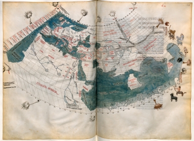
This conic projection world map is from the Ptolemy unfinished Atlas 'Cosmographia' from 1485. The Atlas was made for Louis de Bruges -Prince of Steenhuis- by the copyist and cartographer Jan van Kriekenborch. It was later held by King France Louis XII with his arms and portrait repainted by Jean Perréal. The twelve signs of the zodiac are staggered along the parallels on the right side of the map, under their animal or human symbol. Virgo, represented praying in the manner of the Virgin of the Flemish Annunciations, is dressed in a blue and white drapery dress. Gemini, Libra and Aquarius are depicted naked, Gemini are represented as Adam and Eve. Pisces is in the 'Theriodis Sinus', the Bay of the Beasts. The closed Indian Ocean is named 'Prasodis mare' and in Africa we can see the mythical Mountains of the Moon at the source of the Nile River.
|
|
Note:
|
Original is a manuscript double page world map in Ptolemys unfinished 'Cosmographia' of 1485 with 26 other regional maps.
|
|
Note:
|
Titles from the provenance library.
|
|
Note:
|
The land is white with seas in green with darker ripples. The sea names are in capital letters and rivers in minuscule, both in black ink. As for the place names the same applies, main regions are in capital letters and marginal regions in minuscule, all in red ink.
|
|
Note:
|
The map has 12 windheads blowing into trumpets representing the classic winds, 9 in black and white and the 3 on the right side in color. Also on the right side of the map there are the 12 colored representations of the zodiac signs.
|
|
Note:
|
Relief is shown by shading and bathymetric relief with gradient tints. The mountains are colored grey.
|
|
Note:
|
Latitude and longitude lines on the left and top/bottom respectively.
|
|
Reference:
|
Fischer, J. Claudii Ptolemaei Geographiae codex Urbinas graecus 82: phototypice depictus consilio et opera curatorum Bibliothecae Vaticanae, vol. 1, p. 214, 325-327
|
|
Reference:
|
Burin, E. Manuscript Illumination in Lyons 1473-1530, p. 39
|
|
Reference:
|
Jacob, M. Dans l'atelier des Colombe, Bourges, 1470-1500: la représentation de l'Antiquité en France à la fin du XVe siècle, p. 97
|
|
Reference:
|
Vagnon, E. Les fleuves dans les cartes médiévales: l'exemple du Nil, Itineraria, vol. 1, p. 229
|
|
Reference:
|
Chatelet, A. Nouvelles de l'enluminure, Art de l'enluminure, no. 33, p.74
|
|
Reference:
|
Bräm, A. Zum adaptierten Stifterbild in der spätmittelalterlichen Buchmalerei, Manuscripts in Transition. Recycling Manuscripts, Texts and Images, p. 254-255, 259
|
|
Reference:
|
Deldicque, M. Etre mécène à l'aube de la Renaissance. L'amiral Louis Malet de Graville
|
|
Reference:
|
BNF, Archives et manuscrits https://archivesetmanuscrits.bnf.fr/ark:/12148/cc63679t
|
|
Subject:
|
Europe -- Maps
|
|
Subject:
|
Arabian Peninsula -- Maps
|
|
Subject:
|
Africa -- Maps
|
|
Subject:
|
World -- Maps
|
|
Geographic Area:
|
Europe
|
|
Geographic Area:
|
Africa
|
|
Geographic Area:
|
Arabian Peninsula
|
|
Geographic Area:
|
World
|
|
Relation Note:
|
F. 103v-104 . Mappemonde. Double page. — Projection conique simple. — Pas de cadre. — Mesures en stades (au nord, « longitudo stadiorum 40824 / 21 parallelum per Thylem », au sud, « Australissimum et oppositum illi per Meroe in qua maxima dies. / longitudo stadiorum 86333 fere »). L’espace entre les parallèles est variable et irrégulier (entre 1 mm et 1,8 mm). Au sud de l’Équateur, il n’y a plus de graduations. La longitude est comprise entre zéro et 180 (espace régulier entre les graduations : 2,2 mm). Méridiens et parallèles obliques, convergeant vers les pôles de part et d’autre de l’Équateur, tracés en noir sur les terres et les mers. — Douze vents autour de la carte. Leur nom n’est pas systématiquement inscrit (quand il l’est, en minuscules rouges). Aquilo, Vulturnus, Africus, Caurus. Ils sont représentés à la manière antique, par une tête échevelée aux joues gonflées, soufflant dans une trompe, avec différentes expressions. — La décoration n’est pas achevée : certains vents sont en couleur (page de droite, mais ce ne sont pas forcément ceux qui sont nommés), d’autres en noir et blanc à la plume (page de gauche). — Les douze signes du zodiaque sont échelonnés le long des parallèles, sous leur symbole animal ou humain, à la droite de la carte. Jolies miniatures, en particulier pour le signe de la Vierge, représentée à la manière de la Vierge des Annonciations flamandes, vêtue d’une robe au drapé bleu et blanc. Personnages nus (Gémeaux, Balance, Verseaux). — L’Océan Indien, fermé, se nomme Prasodis mare. — Légende près des monts de la Lune : Ab His Montibus Nili Paludes.
|
|
Pub Title:
|
Cosmographia
|
|
Pub Author:
|
Ptolemy, ca. 90-ca. 168
|
|
Pub Year:
|
1485
|
|
Pub location:
|
Ghent
|
|
Pub location:
|
Bruges
|
|
Provenance:
|
Bibliothèque Nationale de France
|
|
Provenance:
|
https://catalogue.bnf.fr/ark:/12148/cb40670404f
|
|
Provenance Call No.:
|
LATIN-4804
|
|
MUST holding:
|
https://must.primo.exlibrisgroup.com/permalink/853MUST_INST/171sgkf/alma991002923430205076
|