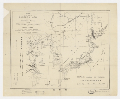
Detail View: Old Maps Collection: Map of a part of Eastern Asia to show the commercial positions of the productive coal fields of Yesso, Japan = 亜細亜東部之圖
|
Barcode:
|
4687820500201
|
|
Title:
|
Map of a part of Eastern Asia to show the commercial positions of the productive coal fields of Yesso, Japan = 亜細亜東部之圖
|
|
Original Title:
|
Map of a part of Eastern Asia to show the commercial positions of the productive coal fields of Yesso, Japan = 亜細亜東部之圖
|
|
Contributor:
|
Smith Lyman, Benjamin
|
|
Contributor:
|
Kada, T.
|
|
Category:
|
Thematic Maps
|
|
Type:
|
Printed
|
|
Language:
|
English
|
|
Language:
|
Japanese
|
|
Create Year:
|
1876
|
|
Format:
|
JPEG, 9400 × 7800, 69.2MB
|
|
Scale:
|
1:10,000,000 (E 114°48ʹ00ʺ--E 148°27ʹ00ʺ/N 50°27ʹ00ʺ--N 28°34ʹ00ʺ)
|
|
Physical Map Dimension (cm):
|
25 × 32
|
|
Note:
|
"compiled from various sources by Benjamin Smith Lyman, chief geologist, and T. Kada, assistant geologist. 17 May 1877."
|
|
Subject:
|
Coal mines and mining
|
|
Geographic Area:
|
Japan
|
|
Geographic Area:
|
China
|
|
Pub Author:
|
Smith Lyman, Benjamin
|
|
Pub Year:
|
[1876]
|
|
Pub location:
|
Tokyo
|
|
Provenance:
|
Harvard Map Collection - Harvard College Library
|