Detail View: Old Maps Collection:
|
Barcode:
|
687800354663G
|
|
Original Title:
|
[Planisphère nautique]
|
|
Contributor:
|
Caverio, Nicolo di, fl. 1502, cartographer
|
|
Category:
|
Sea Charts
|
|
Type:
|
Manuscripts
|
|
Language:
|
Latin
|
|
Language:
|
Portuguese
|
|
Language:
|
Spanish
|
|
Create Year:
|
[ca. 1506]
|
|
Format:
|
JPEG 2000, 14288 x 14528, 22MB
|
|
Scale:
|
[ca. 1:14,000,000].
|
|
Physical Map Dimension (cm):
|
108 x 210 cm, on sheet 111 x 232 cm
|
|
Note:
|
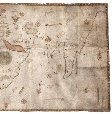
This chart is composed by 10 parchment sheets and was one of the primary sources used to make the Waldseemüller map in 1507. The similarities between this chart and the Cantino world map are striking and many authors believe it to be copied from it, most probably in Lisbon or Genoa. The Cantino map was in Genoa toward the end of 1502 and presumably the following few years. The east coast of North America is drawn with surprising accuracy, which could be explained by the João Fernandes Lavrador (1453-1501) and Pêro de Barcelos (fl. 15--) explorations from 1495 and 1498, and again by John Cabot (ca. 1450-ca. 1500) in 1498 under the orders of King Manuel I of Portugal. As well as the Brazilian coastline by Portuguese explorer Pedro Álvares Cabral (1467-1520) exploration in 1500.
|
|
Note:
|
Original is a manuscript nautical chart on 10 parchment sheets, 115 x 225 cm.
|
|
Note:
|
Title from provenance library.
|
|
Note:
|
There are eighteen 32-point compass roses, to which 17 have an arrow with a star indicating north and a cross on the east point. The center compass rose is placed in the center of a smaller round world map with the Zodiac around it. The compass roses are colored red, green and gold with rhumb lines for the principal winds in black, half-winds in green and quarter-winds in red. Near the left border of the map there is a gold half moon and a red sun on the right border. In total there are 29 flags on the map, 15 from Arabic nations, 8 Portuguese and 6 Spanish; there are also 10 Portuguese 'padrões', all in Africa. In Europe appear four castles, with the Portuguese, Spanish, English and German flags; a Turkish tent and, on the UK, the coat of arms of England and Scotland. In Africa are three castle, two with the Portuguese flag, and a tent in Egypt. On the continent can also be seen illustrations of animals, a lion, a giraffe and an elephant; the Red Sea is colored red. In the Middle East Jerusalem, Mecca and Babylonia are marked with castles and a tower respectively, with a yurt tent up north for Tartary. In South America can be seen tress and and some birds.
|
|
Note:
|
There are 7 table of leagues on the map, 6 horizontal and 1 vertical. They are inside an ornamented red border.
|
|
Note:
|
Tropic of Cancer, Equator and Tropic of Capricorn drawn in red.
|
|
Note:
|
Land masses outlined in green with islands colored green, red, blue or yellow. Place names written in red and black, most important place names inside banderoles.
|
|
Note:
|
Relief shown pictorially.
|
|
Note:
|
The Tropics, the Equator and Seas are written in Latin, but place names are written mostly in Portuguese with a few exceptions in Spanish.
|
|
Note:
|
Map outlined in looped border inside red fillets, except on the left border which is replaced by a latitude line.
|
|
Reference:
|
Cortesão, A. Portugalliae Monumenta Cartographica, vol. I, p. 8-11
|
|
Reference:
|
Gaspar, J. A. Blunders, Errors and Entanglements: Scrutining the Cantino planisphere with a Cartometric Eye, Imago Mundi, vol. 64, part 2, pp. 181-200
|
|
Reference:
|
Foncin, M. Catalogue des cartes nautiques sur vélin conservées au Département des cartes et plans, 133
|
|
Reference:
|
Carlos S. Mapas antiguos del mundo
|
|
Subject:
|
World -- Maps
|
|
Geographic Area:
|
World
|
|
Geographic Area:
|
Central America
|
|
Geographic Area:
|
South America
|
|
Geographic Area:
|
Europe
|
|
Geographic Area:
|
Africa
|
|
Geographic Area:
|
Asia
|
|
Provenance:
|
Bibliothèque Nationale de France
|
|
Provenance:
|
https://catalogue.bnf.fr/ark:/12148/cb40611546n
|
|
Provenance Call No.:
|
GE SH ARCH-1
|
|
MUST holding:
|
https://must.primo.exlibrisgroup.com/permalink/853MUST_INST/171sgkf/alma991003032549405076
|