Detail View: Old Maps Collection: North-East Atlantic, North Sea and Baltic Sea, Mediterranean Sea, Black Sea, Caspian Sea and Red Sea
|
Barcode:
|
3687800354614C
|
|
Title:
|
North-East Atlantic, North Sea and Baltic Sea, Mediterranean Sea, Black Sea, Caspian Sea and Red Sea
|
|
Original Title:
|
[Atlantique Nord-Est, Mer du Nord et Mer Baltique, Mer Méditerranée, Mer Noire, Mer Caspienne et Mer Rouge]
|
|
Contributor:
|
Homem, Diogo, ca. 1520-1576, cartographer
|
|
Category:
|
Sea Charts
|
|
Type:
|
Manuscripts
|
|
Language:
|
Portuguese
|
|
Language:
|
Latin
|
|
Create Year:
|
[ca. 1558]
|
|
Format:
|
JPEG 2000, 13420 × 9886, 18MB
|
|
Page No.:
|
3
|
|
Scale:
|
Scale not given.
|
|
Physical Map Dimension (cm):
|
53 x 76 cm, on sheet 72 x 93 cm
|
|
Note:
|
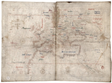
These sheet belongs to an atlas, or rather a group of unfinished 8 loose sheets, attributed to Diogo Homem; making it his work about which more has been written. Even not signed the work is clearly Homem's and is actually one which presents features not found in any other in his vast series of works. It is in fact the only work where he uses Portuguese and Latin, the former he never once used it again in any other of his works, even though it was his native language. This chart is of the coasts of Europe, Asia and Africa including Iceland, the British Islands, Azores and Cape Verde Islands. No other regional chart of Europe by Diogo Homem covers so large an area.
|
|
Note:
|
Original is a manuscript sheet on vellum from an Atlas by Diogo Homem, 61 x 83 cm.
|
|
Note:
|
Title from provenance library.
|
|
Note:
|
There are three 32-point compasses roses on the chart, two with a fleur-de-lis indicating north and one with an arrow indicating north. The rhumb lines for the principal winds are in black, the half-winds in green and the quarter-winds in red. There is an unfinished cartouche intended for the table of leagues on the upper left corner.
|
|
Note:
|
Relief shown pictorially.
|
|
Note:
|
Tropic of Cancer and Arctic Circle in red line.
|
|
Note:
|
Place names in red and black.
|
|
Note:
|
Map in Portuguese and Latin.
|
|
Note:
|
Map outlined in simple fillet.
|
|
Reference:
|
Cortesão, A. Portugaliae Monumenta Cartographica, vol. 2, pp. 49-51
|
|
Reference:
|
Foncin, M. Catalogue des cartes nautiques sur vélin conservées au Département des cartes et plans, 36
|
|
Reference:
|
Pflederer, R. Census of Portolan Charts & Atlases: as reported and listed by the noted scholars of the genre in their works ranging from 1897 to 2008, p. 50
|
|
Subject:
|
Europe -- Maps
|
|
Geographic Area:
|
Europe
|
|
Geographic Area:
|
Africa
|
|
Geographic Area:
|
Mediterranean Sea
|
|
Geographic Area:
|
Middle East
|
|
Relation Note:
|
[3]
|
|
Pub Title:
|
[Atlas nautique portugais].
|
|
Pub Author:
|
Homem, Diogo, ca. 1520-1576
|
|
Pub Year:
|
[ca. 1558]
|
|
Pub location:
|
[S.l.]
|
|
Provenance:
|
Bibliothèque Nationale de France
|
|
Provenance:
|
https://catalogue.bnf.fr/ark:/12148/cb40611727x
|
|
Provenance Call No.:
|
GE C-5086 (1 RES)
|
|
MUST holding:
|
https://must.primo.exlibrisgroup.com/permalink/853MUST_INST/reglfj/alma991003025449705076
|