Detail View: Old Maps Collection: 廣東省地圖 = Carte de la province de Canton. Part 7
|
Barcode:
|
4687820501139
|
|
Title:
|
廣東省地圖 = Carte de la province de Canton. Part 7
|
|
Original Title:
|
廣東省地圖 = Carte de la province de Canton. Part 7
|
|
Contributor:
|
Anonymous
|
|
Category:
|
General Maps
|
|
Type:
|
Printed
|
|
Language:
|
Chinese
|
|
Format:
|
JPEG2000, 5251 x 7135, 67.4MB
|
|
Scale:
|
Scale not given
|
|
Physical Map Dimension (cm):
|
111 x 175
|
|
Note:
|
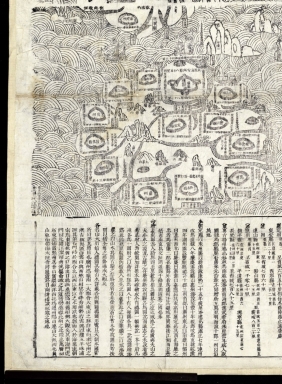
At the bottom, there is a presentation titled "廣東全省圖說" (guang dong quan sheng tu shuo), literally "presentation of the map of Guangdong Province." The map shows the distances between the fu (府), the zhou (州) and the capital city of the province There is also a brief history of the city of Guangzhou (廣州).
|
|
Reference:
|
"繪畫與圖添入, 繪成全省總圖一幅, 冊說一本, 十府九州, 各為一圖附之, 以衛所州縣為圖八十有八, 每圖各具一說. 本件實為一總圖".
|
|
Geographic Area:
|
Guangdong Sheng (China)
|
|
Geographic Area:
|
Macao (China)
|
|
Relation Note:
|
Part 1 : 4687820501133 ; Part 2 : 4687820501134 ; Part 3 : 4687820501135 ; Part 4 : 4687820501136 ; Part 5 : 4687820501137 ; Part 6 : 4687820501138 ; Part 8 : 4687820501140 ; Part 9 : 4687820501141
|
|
Pub Title:
|
廣東全省圖
|
|
Provenance:
|
Bibliothèque nationale de France
|