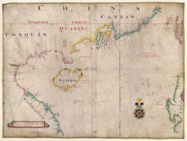
Detail View: Old Maps Collection: Gulf of Tonkin to Luzon and Formosa

|
Barcode:
|
3687800354308C
|
|
Title:
|
Gulf of Tonkin to Luzon and Formosa
|
|
Original Title:
|
[Golfe du Tonkin jusqu'à Luçon et Formose]
|
|
Contributor:
|
Thornton, John, 1641-1708, hydrographer
|
|
Category:
|
Sea Charts
|
|
Type:
|
Manuscripts
|
|
Language:
|
English
|
|
Language:
|
Latin
|
|
Language:
|
Portuguese
|
|
Create Year:
|
1699
|
|
Format:
|
JPEG 2000, 12712 x 9592, 24MB
|
|
Scale:
|
Scale not given.
|
|
Physical Map Dimension (cm):
|
8 x 105 cm, on sheet 92 x 112 cm
|
|
Note:
|
This navigational chart was clearly made from a map of the same region by Joan Blaeu in 1668. It depicts the Gulf of Tonkin with the island of Hainan, the South China Sea to the Philippines in the East with the Luzon island visible on the right edge of the map, and Taiwan still named 'Formosa' up north. Also present are the northern part of the Paracel Islands with the inset 'The triangle' on its northeast side. The chart is obviously made for navigational purposes as toponyms are scarce to some extent, even though quite a number of soundings are given, specially closer to the coast lines. On China and Hainan Island can be seen a concentration of notes with instructions for pilots and overall information about the place and what can be found in each place.
|
|
Note:
|
Original is a colored manuscript map on parchment, 78 x 105 cm.
|
|
Note:
|
Title from provenance library.
|
|
Note:
|
There is a 32-point compass rose on the map with a fleur-de-lis indicating north, colored blue, yellow, red, green and magenta. The rhumb lines for the principal winds are black, half-winds are green and quarter-winds are red.
|
|
Note:
|
Table of leagues on the left bottom corner of the map above the authors note in ornamented cartouche, colored red, blue, yellow and magenta.
|
|
Note:
|
Relief shown pictorially and bathymetric relief by soundings.
|
|
Note:
|
Latitude line roughly in the middle of the map in red, yellow and blue interchangeably.
|
|
Note:
|
Landmasses outlined in blue, green, yellow and magenta with small islands painted in the same colors.
|
|
Note:
|
Line for the Tropic of Cancer in red.
|
|
Note:
|
Place names on land are written in black and on water in red.
|
|
Note:
|
Map with yellow border.
|
|
Note:
|
Macao in Asia maps.
|
|
Note:
|
Macao in East Indies maps.
|
|
Note:
|
Macao and its surroundings.
|
|
Reference:
|
Foncin, M. Catalogue des cartes nautiques sur vélin conservées au Département des cartes et plans, p. 297
|
|
Reference:
|
Pflederer, R. Census of Portolan Charts & Atlases: as reported and listed by the noted scholars of the genre in their works ranging from 1897 to 2008, p. 69
|
|
Subject:
|
Nautical Chart
|
|
Geographic Area:
|
China
|
|
Geographic Area:
|
South China Sea
|
|
Geographic Area:
|
Hainan Sheng (China)
|
|
Geographic Area:
|
Paracel Islands
|
|
Geographic Area:
|
Taiwan
|
|
Geographic Area:
|
Vietnam
|
|
Geographic Area:
|
Philippines
|
|
Provenance:
|
Bibliothèque Nationale de France
|
|
Provenance:
|
https://catalogue.bnf.fr/ark:/12148/cb40781812s
|
|
Provenance Call No.:
|
GE SH 18 PF 181 P 5 RES
|
|
MUST holding:
|
https://must.primo.exlibrisgroup.com/permalink/853MUST_INST/171sgkf/alma991002989549705076
|