Detail View: Old Maps Collection: Map of the South China Sea
|
Barcode:
|
3687800354255D
|
|
Title:
|
Map of the South China Sea
|
|
Original Title:
|
[Carte de la Mer de Chine méridionale]
|
|
Other Title:
|
Mer de Chine, Sud.
|
|
Other Title:
|
Mer de Chine, Méridionale
|
|
Contributor:
|
Blaeu, Joan, 1596-1673, cartographer
|
|
Category:
|
Sea Charts
|
|
Type:
|
Manuscripts
|
|
Language:
|
Dutch
|
|
Language:
|
Spanish
|
|
Language:
|
Portuguese
|
|
Create Year:
|
1668
|
|
Format:
|
JPEG 2000, 14543 × 13090, 24MB
|
|
Scale:
|
Scale not given.
|
|
Physical Map Dimension (cm):
|
81 x 97 cm, on sheet 91 x 112 cm
|
|
Note:
|
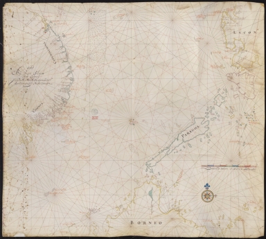
This Portolan chart is typical of the Dutch cartography of the 17th century with Portuguese influence. On it are depicted the South China Sea and part of the Celebes Sea. On the left there is Vietnam East coast with the Paracels in the Vaz Dourado type, although with the triangular set on its northeast side that started to emerge on Dutch maps by the mid-16th century. It is also represented the north of Borneo and western of the Philippines Islands, Palawan -named 'Paragoa', the unnamed Mindoro, and Luçon -named Lucon.
|
|
Note:
|
Original is a manuscript chart on parchment, 84 x 95 cm.
|
|
Note:
|
Title from provenance library.
|
|
Note:
|
There is one 32-point compass rose on the map with a fleur-de-lis indicating north and a cross on the East point. It is colored yellow, blue, green, red and magenta with rhumb lines for the principal winds in black, half-winds in green and quarter-winds in red.
|
|
Note:
|
Scale line in miles in yellow, blue, green, red and magenta.
|
|
Note:
|
Relief shown pictorially and bathymetric relief by soundings.
|
|
Note:
|
Latitude line on the left edge of the map in green, yellow and magenta interchangeably.
|
|
Note:
|
Landmasses outlined in blue, yellow and magenta with small islands colored in the same colors.
|
|
Note:
|
Land nomenclature in black with sea nomenclature in red.
|
|
Reference:
|
Destombes, M. Cartes hollandaises : la cartographie de la Compagnie des Indes Orientales, 1593-1743, n.º 84, p. 57
|
|
Reference:
|
Foncin, M. Catalogue des cartes nautiques sur vélin conservées au Département des cartes et plans, p. 297
|
|
Reference:
|
Pflederer, R. Census of Portolan Charts & Atlases: as reported and listed by the noted scholars of the genre in their works ranging from 1897 to 2008, p. 69
|
|
Subject:
|
China -- Maps
|
|
Geographic Area:
|
China
|
|
Geographic Area:
|
Vietnam -- coasts
|
|
Geographic Area:
|
Borneo -- coasts
|
|
Geographic Area:
|
Paracel Islands
|
|
Geographic Area:
|
Philippines
|
|
Geographic Area:
|
South China Sea
|
|
Geographic Area:
|
Celebes Sea
|
|
Provenance:
|
Bibliothèque Nationale de France
|
|
Provenance:
|
https://catalogue.bnf.fr/ark:/12148/cb40781809w
|
|
Provenance Call No.:
|
GE SH 18 PF 181 P 2 RES
|
|
MUST holding:
|
https://must.primo.exlibrisgroup.com/permalink/853MUST_INST/171sgkf/alma991002985449705076
|