Detail View: Old Maps Collection: North Indian Ocean with Arabia and India
|
Barcode:
|
3687800354643E
|
|
Title:
|
North Indian Ocean with Arabia and India
|
|
Original Title:
|
[Océan Indien Nord avec l'Arabie et l'Inde]
|
|
Other Title:
|
Atlas Miller
|
|
Other Title:
|
Lopo Homem-Reineis Atlas
|
|
Contributor:
|
Homem, Lopo, fl. 1517-1565, cartographer
|
|
Contributor:
|
Reinel, Pedro, ca. 1464-ca. 1542, cartographer
|
|
Contributor:
|
Reinel, Jorge, ca. 1502-ca. 1572, cartographer
|
|
Contributor:
|
António de Holanda, 1480?-1556, illustrator
|
|
Contributor:
|
Santarém, Manuel Francisco de Barros e Sousa de Mesquita de Macedo Leitão e Carvalhosa, 1791-1856, 2nd viscount of, former owner
|
|
Contributor:
|
Miller, Emmanuel, 1812-1886, former owner
|
|
Category:
|
Sea Charts
|
|
Type:
|
Manuscripts
|
|
Language:
|
Portuguese
|
|
Language:
|
Latin
|
|
Create Year:
|
1519
|
|
Format:
|
JPEG 2000, 14656 × 10606, 24MB
|
|
Page No.:
|
3
|
|
Scale:
|
Scale not given.
|
|
Physical Map Dimension (cm):
|
41 x 60 cm, on sheet 53 x 68 cm
|
|
Note:
|
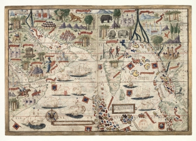
This map is from an Atlas known as Atlas Miller or Lopo Homem-Reineis Atlas. It was a joint work of cartographers Lopo Homem, Pedro Reinel and Jorge Reinel, and illustrated by Flemish miniaturist António de Holanda. It is considered one of the most beautiful Renaissance cartographic documents from Portugal. According to some authors the Atlas formed by 6 sheets is missing a 7th sheet which probably included a map of Africa. The five sheets with the maps were sold by Jacques Charavey -a Paris bookseller- to Portuguese viscount of Santarém that later sold them to Emmanuel Clement Miller, hence the name Miller Atlas. In 1897 Millers widow sold it to the Bibliothèque Nationale de France. The mapamundi sheet was later found in an auction in London in 1930 with the no. 91 in a catalogue of Sotheby & Co. The buyer -Marcel Destombes- with the help of experts, concluded in 1939 that belonged to the Miller Atlas and in 1976 donated it to Bibliothèque Nationale de France. The title page bears a later inscription -probably after 1559- with the arms of Catherine de Medici, queen of France. It is thought to have been an offering from King Manuel I of Portugal to Francis I of France. However many authors agree that it had a political ground for it secretly denies the idea that the actual circumnavigation of the globe was possible and it was made to hinder Magellan’s voyage under the Spanish King. Given its rich illuminations, this is one of the most beautiful charts in the Atlas Miller. The map extends from Arabia to Myanmar with the northwest point of Sumatra. On Cape Guardafui the illumination depicts the nearby mountains by the Latin Ptolemaic name of 'Elephans Mons' [i.e. Mount Elephant]. The chart shows the Horn of Africa and part of the Red Sea, Arabia, the Persian Gulf, Iran, India -including Ceylon-, the west coast of the Indo-Chinese Peninsula as far as the straits of Malacca, and part of the island of Sumatra. In terms of cartographic accuracy, it is clearly divided into two parts: the area west of Ceylon is generally a faithful depiction, only using ancient geography to counter contemporary lack of knowledge about the inland areas; from Coromandel to the east, there are far more imperfections and far greater reliance on Ptolemaic geography. The Indian Ocean has two different names, in the part that corresponds to the Arabian Sea, it is called 'Mare Indicum', while the area showing the Gulf of Bengal is named 'Pealegus Indicus'. The Ptolemaic name 'Sinus Gangeticus', the gulf of the Ganges, appears further north, in the upper reaches of the gulf. The Persian Gulf is called 'Mare Persicum' and as was then standard usage, 'Sinus Arabicus' is used to refer to the Gulf of Aden and 'Rubrum Mare' for the Red Sea.
|
|
Note:
|
Original is a manuscript vellum Atlas with 6 sheets with both recto and verso, 42 x 59 cm.
|
|
Note:
|
Title from provenance library.
|
|
Note:
|
The map is very ornamented with six Portuguese flags and and four heraldic devices. On water there are 11 vessels: three Portuguese, two with the cross of the Order of Christ; seven Muslim ship with the half-moon depicted on their sails and one Chinese junk. On land there are several illustrations of buildings, mostly castles indicating important cities, natives and animals such as horses, camels, elephants, lions, rhinos and different species of birds and flora. There is a 32-point compass rose with an arrow indicating north, colored red, blue, green and gold. As for the rhumb lines the principal winds are in black, the half-winds in green and the quarter-winds in red.
|
|
Note:
|
There is a table of leagues on the bottom left side of the map inside a gold cartouche.
|
|
Note:
|
Relief shown pictorially.
|
|
Note:
|
Equator and Tropic of Cancer in red.
|
|
Note:
|
Landmasses outlined in green with islands colored red, blue, green and gold.
|
|
Note:
|
The map is mainly in Latin but the place names are in Portuguese.
|
|
Note:
|
Map is outlined in simple fillet with a wide gold border.
|
|
Reference:
|
Cortesão, A. Portugaliae Monumenta Cartographica, vol. 1. p. 55-61
|
|
Reference:
|
La Mappemonde Lopo Homem et L'atlas Miller, The Geographical Journal, vol. 94, no. 6, p. 485-492
|
|
Reference:
|
Miró, M. Atlas Miller, p. 286-[296], 311-322
|
|
Reference:
|
龚缨晏. 《米勒之地图集》之谜, 地图, 02期
|
|
Reference:
|
Marques, A.P. Os Descobrimentos e o 'Atlas Miller
|
|
Reference:
|
Denucé, J. Les origines de la cartographie portugaise et les cartes des Reinel
|
|
Reference:
|
Pastoureau, M. Sur la route des deux Indes http://expositions.bnf.fr/marine/arret/03-2-2.htm
|
|
Subject:
|
Atlas
|
|
Subject:
|
Charts
|
|
Subject:
|
Early works to 1800
|
|
Geographic Area:
|
Indian Ocean
|
|
Geographic Area:
|
Arabian Peninsula
|
|
Geographic Area:
|
India
|
|
Geographic Area:
|
Arabia
|
|
Geographic Area:
|
Iran
|
|
Geographic Area:
|
Pakistan
|
|
Geographic Area:
|
Sri Lanka
|
|
Geographic Area:
|
Myanmar
|
|
Geographic Area:
|
Indonesia
|
|
Geographic Area:
|
Sumatra (Indonesia)
|
|
Relation Note:
|
[Sheet 3 reto]
|
|
Pub Title:
|
[Atlas nautique du Monde, dit Atlas Miller]
|
|
Pub Author:
|
Homem, Lopo, fl. 1517-1565.
|
|
Pub Year:
|
1519
|
|
Pub location:
|
[S.l.]
|
|
Provenance:
|
Bibliothèque Nationale de France
|
|
Provenance:
|
https://catalogue.bnf.fr/ark:/12148/cb40887480s
|
|
Provenance Call No.:
|
GE DD-683 (3 RES)
|
|
MUST holding:
|
https://must.primo.exlibrisgroup.com/permalink/853MUST_INST/171sgkf/alma991003027349805076
|