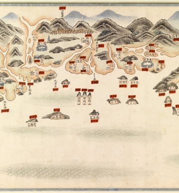
Detail View: Old Maps Collection: 南中國海岸圖 = Carte des côtes sud de la Chine. Part 12

|
Barcode:
|
4687820501123
|
|
Title:
|
南中國海岸圖 = Carte des côtes sud de la Chine. Part 12
|
|
Original Title:
|
南中國海岸圖 = Carte des côtes sud de la Chine. Part 12
|
|
Contributor:
|
Anonymous
|
|
Category:
|
General Maps
|
|
Type:
|
Manuscripts
|
|
Language:
|
Chinese
|
|
Create Year:
|
18--?
|
|
Format:
|
JPEG2000, 5237 x 5630, 39MB
|
|
Scale:
|
Scale not given
|
|
Note:
|
The map depicts the Chinese coastline from southern Fujian Province (福建), then Guangdong Province (廣東), Hainan Island (海南) to the Vietnam border.
|
|
Subject:
|
Coasts
|
|
Geographic Area:
|
Fujian Sheng (China)
|
|
Geographic Area:
|
Guangdong Sheng (China)
|
|
Geographic Area:
|
Hainan Sheng (China)
|
|
Geographic Area:
|
Macao (China)
|
|
Relation Note:
|
Part 1 : 4687820501112 ; Part 2 : 4687820501113 ; Part 3 : 4687820501114 ; Part 4 : 4687820501115 ; Part 5 : 4687820501116 ; Part 6 : 4687820501117 ; Part 7 : 4687820501118 ; Part 8 : 4687820501119 ; Part 9 : 4687820501120 ; Part 10 : 4687820501121 ; Part 11 : 4687820501122 ; Part 13 : 4687820501124 ; Part 14 : 4687820501125 ; Part 15 : 4687820501126 ; Part 16 : 4687820501127 ; Part 17 : 4687820501128 ; Part 18 : 4687820501129 ; Part 19 : 4687820501130 ; Part 20 : 4687820501131
|
|
Pub Title:
|
南中國海岸圖 = Carte des côtes sud de la Chine
|
|
Pub Author:
|
Anonymous
|
|
Pub Year:
|
18--?
|
|
Pub location:
|
[China]
|
|
Provenance:
|
Bibliothèque nationale de France
|